

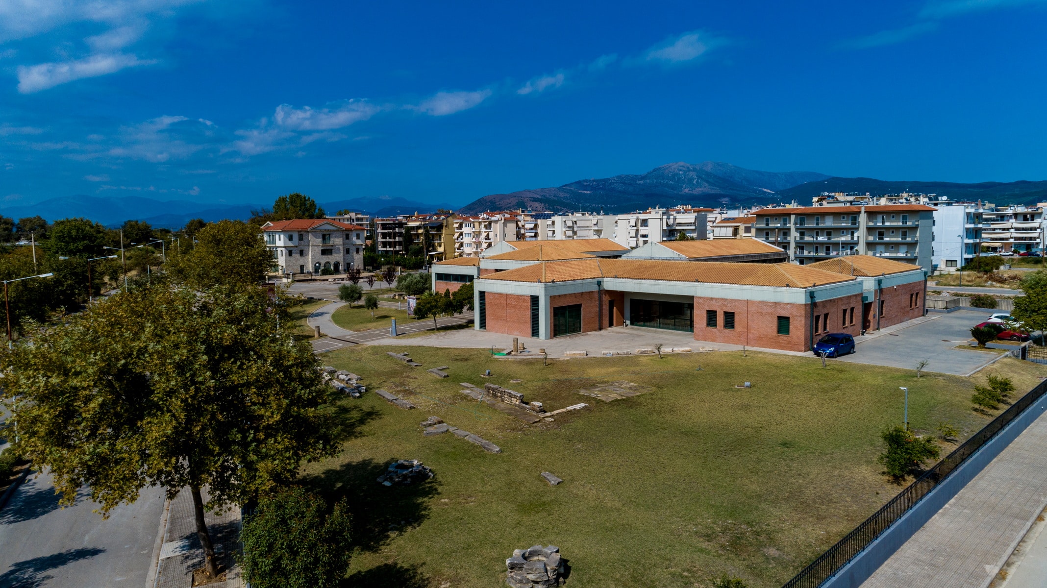
The Archaeological Collection of Arta was founded in 1973, housed in the renovated dining room of Parigoritissa Monastery. This collection included finds from Arta and the wider area. However, the huge volume of portable finds from the salvage excavations of the last decades of the 20th century made it imperative to establish an Archaeological Museum in the city, both for the presentation – exhibition of the most important of them, and for the safe storage of the rest. Thus, the new Archaeological Museum of Arta was opened in 2009 near the Arachthos river and the historic bridge.
The organization of the museum’s permanent exhibition was based on modern museological concepts that project the daily life and the characteristics of the ancient city’s society. The museum outlines Amvrakia’s historical route through three main sections. The first section is dedicated to public life, the second to burial customs, and the third to private life. Finally, there are two other smaller sections, the “”introduction to the exhibition”” with findings from prehistoric and early times and the “”end of Amvrakia”” with findings concerning the last period of the Corinthian colony.
All destinations
Church of Panaghia of “Rodia”
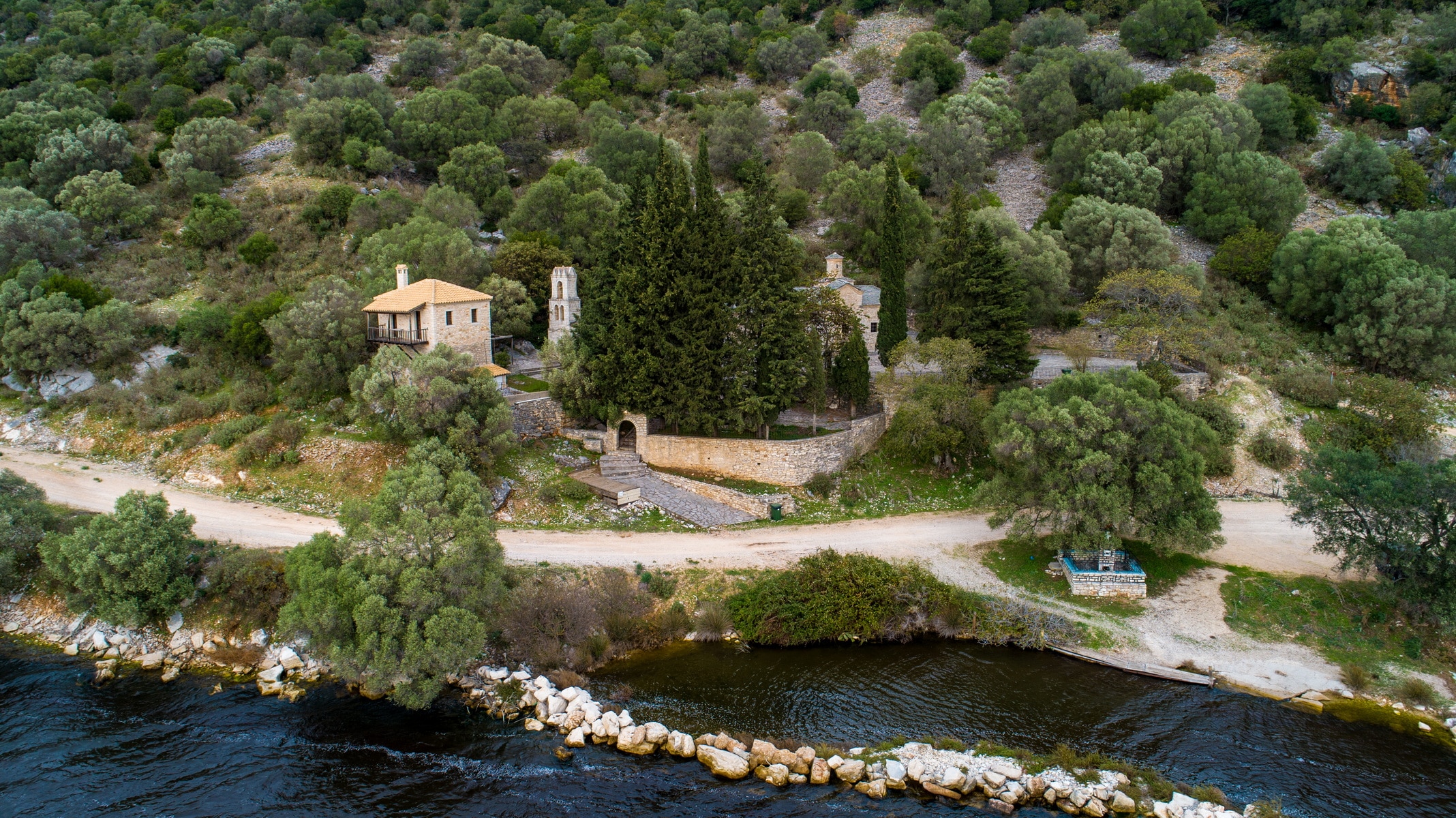
The Monastery of Rodia or Roidia or Rodon to Amaranto (everlasting rose in Greek), dedicated to the Dormition of the Mother of God, is located at the foot of the SW slope of Mount Mavrovounio (altitude 299m.), above the NE shore of the Rodia lagoon, west of Arta and between the villages Vigla- Stroggyli. It was built in 1860, on the place of an older Byzantine katholikon, known in written sources by the nickname “”Rodon Amaranto””, like the Virgin Mary’s icon homonymous iconographic type. Both the newer church and the lagoon received the name “”Rodia”” from the same image.
The foundation time of the Byzantine katholikon is not confirmed. According to Seraphim Xenopoulos, Metropolitan of Arta of the 19th century, it dates back to 970. According to his information, a Stavropegian monastery was erected in this place when Ioannis Tsimiskis was the emperor in Constantinople and Vasilios was the Patriarch. The information is quite accurate, as it is based on specific data provided by the metropolitan and reports that, according to him, were revealed by ancient manuscripts that existed in the monastery and which, unfortunately, are not preserved today. We learn from the same source that the monastery reached great prosperity and owned numerous estates, a fish farm, and four metochia (dependencies), including the Byzantine church of Agios Nikolaos of Rodia in Kirkizates. Panagiotis Aravantinos, a 19th-century chronographer, believed that the monastery was older and dated its foundation in 925. He also mentioned that the monastery had an income of 8,000 grosis a year in the 18th century.
The monastery often took the lead in the struggle against the Turks and became the target of brutal raids many times. In the years of the revolution, it was completely ruined. The Turks seized the estates, and the temple was destroyed. It remained so until 1860, when the exquisite present-day church was built in its place.
It is a large single-aisled, cross-roofed, vaulted basilica with a vaulted narthex and a high dome with a very small diameter, making the temple elegant and graceful. This peculiar dome is also its characteristic trait, and since it is unique in the ecclesiastical architecture of Epirus, it makes the monument even more extraordinary. The tiled roofs reveal the craftsman’s obvious effort to highlight the shape of the cross. The two domes on the vertical antennas of the “”cross”” are externally formed like a pediment, thus contributing to architecture’s variety in the exterior.
The masonry is very elaborate in the corners, with unique exterior decoration, a simple jagged band on the cornices of the main building, and a double one on the cornices of the dome and the niche of the sanctuary. As evident from the masonry, the square narthex was added later, before 1884 without a doubt, which was the year it was illustrated.
The interior of the temple is fully decorated and in excellent condition. According to an inscription on the inner lintel of the south entrance, Samarinian painters illustrated the temple in 1884. The iconographic program, well-known in the years of Ottoman rule, is arranged in zones, with full-length saints underneath, busts of saints in the middle, and evangelical scenes or scenes from the liturgical calendar in the upper zones. Key elements of the style of the representations are the bright colors and the radiant faces with the suave expressions that do not resemble the well-known strictness of the Byzantines but rather approach the hagiographic tradition of Chionades village. The church of Panagia Rodia is a remarkable architectural and hagiographic monument of the post-Byzantine painting tradition.
At the same rocky slope’s foothills, a cave near the temple had been used as a hermitage for many years, as the frescoes’ traces on its walls reveal. According to Aravantinos, the chronographer of Epirus, Saint Vlasios of Sevastia was an anchorite there. Unfortunately, brutal interventions eradicated these murals’ glow, desecrating the area, since the cave had been used as a stable for many years.
Fortress (Kulia) of Koronissia
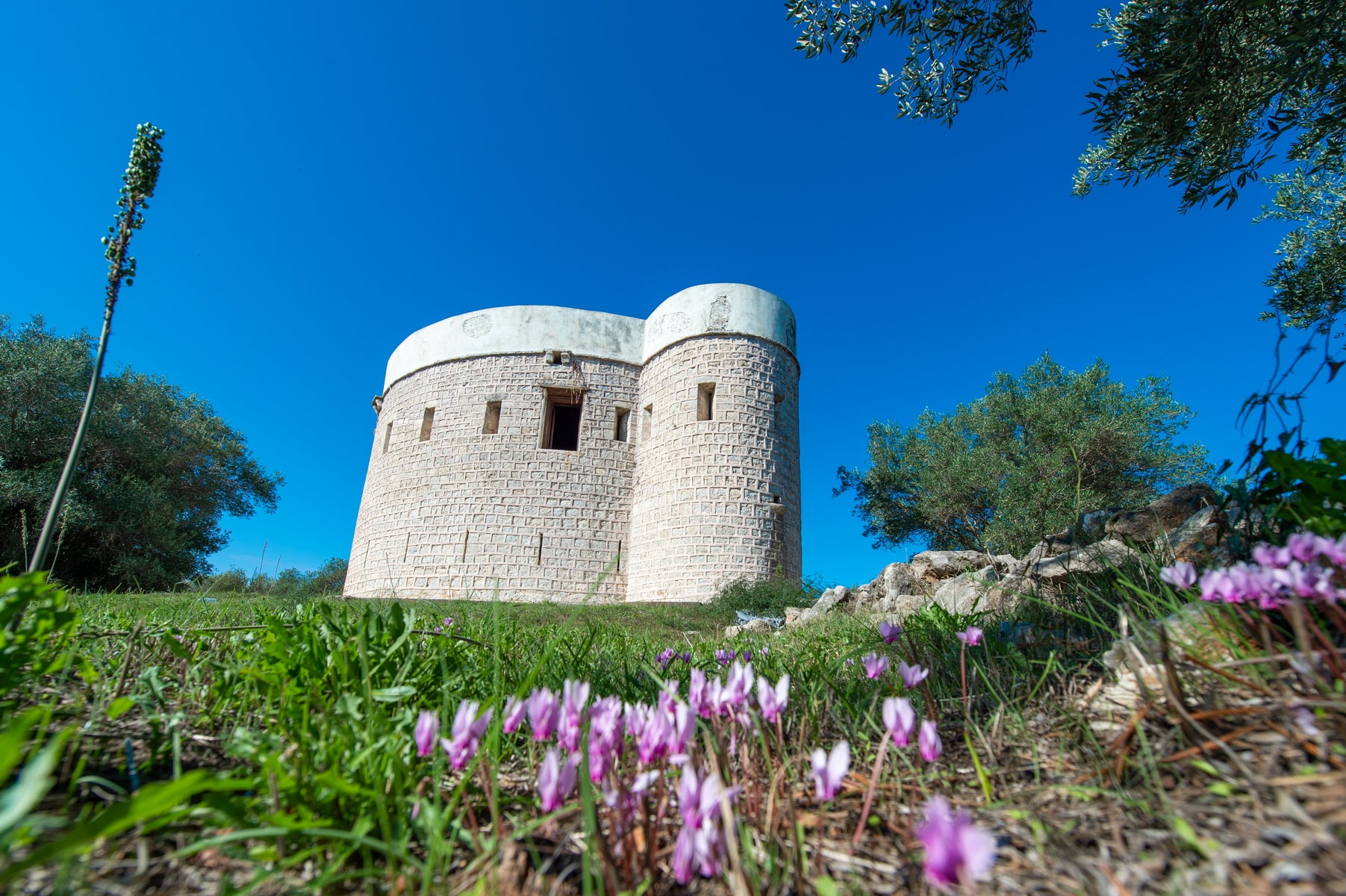
Koulia castle is a small, well-preserved fortress on the island of Koronisia, in the southern part of the settlement. It overlooks the Amvrakikos gulf together with the “”twin”” and identical castle of Laskara, in the homonymous cape that penetrates the gulf from the side of Preveza.
The word “”koulia””, as it was initially called, comes from the Turkish “”kulla”” (Persian “”qulla””) and means the top or tower. Such works are part of a defense network located at critical points from where they supervised the surrounding area.
The fortress of Koronisia is believed to have been built in the early 19th century by Ali Pasha, with designs of the French army colonel Guillaume de Vaudoncourt and under the supervision of the Italian engineer Monteleone.
They are the same architects who built the Pantocrator Fortress in Preveza, the Bastion of Pefkakia in Preveza, and the Fortress of Anthousa in Parga.
According to another hypothesis, the fort was built much later, probably in 1860, at a time when the Turks were trying to strengthen their border defense on the north side of the Amvrakikos Gulf. The area was then on the frontier between Greece and Turkey.
There is, however, the view expressed by Konstantinos Dem. Rosos, according to which the fortress is much older and was originally built by the Venetians. After the battle of Koronisia in 1829 it was occupied by the Greek Army. In 1850, after the exchange of Euboea with Amvrakikos, it fell again into the hands of the Turks.
The castle is circular with two high towers that connect to its perimeter in opposite positions. It has an entrance that is elevated and accessible by a ramp. Today it occasionally hosts various cultural events and sometimes functions as a lending library.
Church of Aghios Vassilios
The Byzantine Church of St. Vasilios of the Bridge is located in Top Alti, a place name meaning the area within the firing range of the castle’s cannons. It received the nickname “”Bridge”” because it lies only 1 km from the historic bridge. The nickname also differentiates the church from the one of St. Vasilios of Agora.
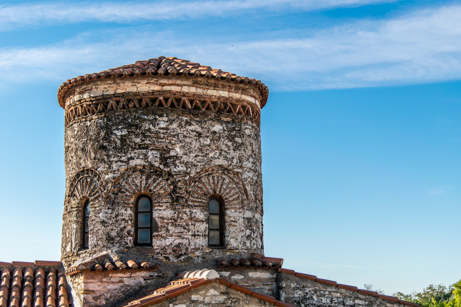
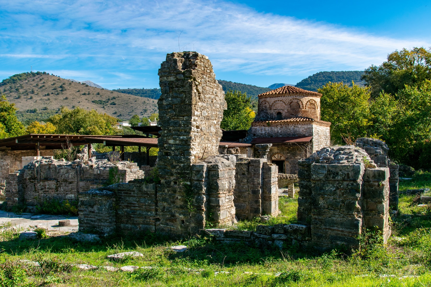
The first written reference to the monument comes from Seraphim Xenopoulos or Byzantio, Metropolitan of Arta, in the 19th century. It is mentioned that the church of St. Vasilios of the Bridge was initially the monastery’s katholikon (central church building), renovated in 1632 by the monk Theoklitos. In 1821 it functioned as a parish church, while in 1852, D. Vlachos, a resident of Arta, altered the monument. Built on the bank of the Arachthos River, the temple was vulnerable to damage and was sometimes earth-coved by the river. In the 20th century, it was covered at a depth of up to 2 meters. Archaeologist P. Vokotopoulos carried out excavation and unearthing works in 1969-1970, studied the monument, and dated it to the second half of the 9th century, correcting its original dating in the 15th century. The church is one of the early monuments of mid-Byzantine times that dates back to the era before the establishment of the Despotate of Epirus, along with the Virgin Mary of Koronisia, Saint Paraskevi of Drakos, the first phase of the church of Aghia Theodora, etc.
Architectural elements: The church has been built in the type of the free cross like the later church of Saint Paraskevi of Drakos. An imposing, cylindrical dome with a conical roof rises at the point where the antennas of the cross meet. According to archaeologist G. Velenis, the upper part of the dome is the result of a later construction phase. This explains its somewhat disproportionate size in relation to the temple. The monument’s floor plan is completed with the square narthex to the west, which extends the vertical antenna of the cross. The narthex is separated from the main temple by two pillars. The arch of the sanctuary is circular and has a trifora window. The roofs’ arches are covered externally with double-pitched roofs on the north and south part and a single-pitched roof on the western part of the main church and the narthex.
The church’s entrance lies on the west side, while the stone floor was created in 1969. Cist graves in the north, south, and west parts of the cross came to light during the excavations. The Holy Altar is also a newer construction.
Exterior decoration: The masonry consists of irregular stones with pieces of bricks or tiles inserted between them, mainly in a horizontal arrangement. The masonry is adorned with ceramic decoration seen in the dome and the eastern arch. Specifically, the arched windows of the dome are defined perimetrically with brick arches, surrounded by a serrated band. A zone consisting of diagonal plinths surrounds the dome a little higher, while a serrated band adorns the window of the arch.
Painting decoration: Four layers of frescoes, painted in different eras, were discovered after the excavation of the church in 1969-1971. According to research, the first temple was not frescoed. It was illustrated for the first time in the second half of the 13th century and after its embankment. This first decorative phase is seriously damaged, but a large part is still preserved, such as the sanctuary’s frescoes with the dominant figure of Our Lady of the Sign, framed by two angels. The figures of a saint, two hierarchs, and an equal number of deacons are also found on the trifora window’s wall. Stefanos, the first martyr, is depicted on the left. Iconographic themes with full-length frontal saints, such as Panteleimon, Kosmas and Damianos, etc., have also been preserved.
The second phase dates to the 16th century. A monumental, full-length figure of the blessing St. Vasilios belongs to this phase. The two newer phases date back to the 17th century, and they include representations such as Saints Constantine and Helen, the baptism of Christ and figures of full-body, and on horseback Saints.
Church of Panaghia “Pantanassa”
Panagia Pantanassa church lies at the northern end of the prefecture of Arta, near Lake Ziros and on the old national road of Ioannina-Preveza. It is located 17 km from Arta and 5 km from Filippiada.
It is a mid-Byzantine monument, built at the heyday of the Despotate of Epirus, one of the two monasteries founded by the despot Michael II Komnenos, as a sign of remorse for his hedonistic life and his bad behavior towards his wife Theodora, later a Saint. The monk Job Melias (13th c.), the biographer of Saint Theodora, provides us with this information.
The katholikon of the Pantanassa monastery was one of the largest temples of the Despotate. It was built in the middle of the 13th century by Michael II, while at the end of the century, the peristyle surrounding the church was added, probably by his son, Nikiforos I. It seems, however, that the monastic complex succumbed early on to the destructive action of natural phenomena. In the 15th century, the katholikon had already suffered significant damage. In the following centuries, the monastery was abandoned. In fact, Seraphim Xenopoulos, Metropolitan of Arta (second half of the 19th century), believes that the monastery was destroyed in 1692. In 1820 the English traveler Thomas Hughes wrote in his book “”Travels in Sicily, Greece, and Albania”” that in the area, there are ruins of a temple under tall trees, whose walls are preserved at a great height. In 1836, the remains of the buildings attracted the attention of Parthenios, abbot of the Prodromos monastery, who repaired the small Saint Vasilios chapel on the south side of the katholikon. This is why the chapel was preserved in recent years, maintaining satisfactory data for its dome’s restoration, a work that Professor P. Vokotopoulos carried out.
Seraphim Xenopoulos, the Byzantios, Metropolitan of Arta, connected for the first time the ruins of the monastery with Panagia Pantanassa at the end of the 19th century. Until 1970, they remained abandoned, embanked, and covered with dense vegetation. In 1971, P. Vokotopoulos started extensive excavation and studies of the katholikon that lasted for years. In addition to many portable finds, important elements were revealed about the morphology of the temple that changed the initial belief about the architectural type it represents. The highlight of these works was the restoration of the chapel’s dome with the ceramic decoration of its masonry.
Today the ruins of the temple of Pantanassa do not allow the visitor to envisage it. The original grandeur of the large building is vaguely indicated, and indeed the small Saint Vasilios chapel is a bystander to its first, imposing image.
Architecture: According to P. Vokotopoulos, the katholikon of the Virgin Mary Pantanassa monastery, with total floor plan dimensions of approximately 27.30x15m, belongs to a rare variant of the complex cruciform inscribed church with evident influences from Constantinople’s architecture.
A total of five domes were formed on its ceilings. The large, central dome rose at the point where the antennas of the cross met. The columns, supporting it in the interior, were of equivalent size. Three of these columns’ bases were found during the excavations. Around the central one, the other four domes were smaller and covered the corner spaces.
The three-part sanctuary had autonomous spaces, defined by vertical walls, which adjoined with each other through openings. To the east, three niches were formed.
To the west of the katholikon, the narthex had three openings to adjoin with the main temple and two entrances, one on the north and one on the south side. The church was surrounded by the ambulatory, a possible work of Nikiforos I and his wife, Anna Palaeologina. The large Π-shaped ambulatory circled all the sides of the Katholikon. At its eastern ends, two domed chapels were formed. We do not know the patron Saint of the northern chapel. Saint Vasilios chapel to the south has been preserved to this day. The ambulatory was supported by a double colonnade, on the south and west side and pillars, on the north.
Inscriptions: On one of the two restored columns on the west side of the ambulatory, there are two inscriptions: The first inscription «Ιω(άννης) Δεσπότ(ης)/ Σπάτας» refers to the Albanian, Gini (Ioannis) Boua Spata, who was despot of Arta between 1374 and 1399. The second inscription is on its left: “”Κ (υρι) ε Ι (ησο) ύ Χ (ριστ) έ Υιέ Θ (ε) ου””, which means Lord Jesus Christ, Son of God.
In another inscription in the northwestern column, the name: “”MICHAEL BOUNILAS”” is engraved.
Finally, the name of Nikiforos I is engraved on a brick slab, which was found during the excavations, probably coming from the ambulatory.
Masonry and exterior decoration: The masonry of the church was built, for the most part, with the Cloisonné Byzantine technique, that is, stones surrounded by one or two rows of bricks. The exterior walls of the katholikon were adorned with three rows of arches, an apparent element of Constantinople’s architecture. The plinths discovered in the excavation revealed ample ceramic decoration characteristics, such as checkered friezes, jagged bands, etc.
Sculpture decoration: The abundant findings of the excavation research revealed an interesting sculpture decoration set from the temple’s interior, characterized by quality and variety.
Initially, there are the main church and the ambulatory’s capitals (few were found complete) that originate from Early Christian and ancient buildings. The traces of gilding that are preserved on several parts are remarkable, while there are many similarities with the capitals of St. Theodora church in Arta.
Another category of sculptures is the marble decoration of the pillars at the temple’s entrances, strongly influenced by the Romanesque, medieval art of Europe.
Finally, the reliefs, mainly from the iconostasis and the temple’s shrines, are classified as Byzantine style.
Murals: Only a few fragments survive from the frescoes of the temple today. Concelebrating hierarchs, full-length saints with scrolls, and belts with geometric decoration are depicted on the north and south walls.
The representation of the Virgin Mary holding Christ on her chest and crowning a rulers’ couple with two children is unique, with particular historical interest. The inscription informs us that it is a depiction of the despot Nikiforos A (1269-1296), his wife Anna, and their two children.
A few traces showed that the katholikon also had frescoes on the exterior walls.
Several burials around the temple reveal that Pantanassa’s area was used as a cemetery after the desolation of the katholikon. In the past, a large, Early Christian pulpit was found near the monastery (today lies in the Archaeological Collection of Parigoritissa). However, we cannot know which church it comes from or whether it had been used in the monastery.
Church of Aghia Paraskevi of Drakos
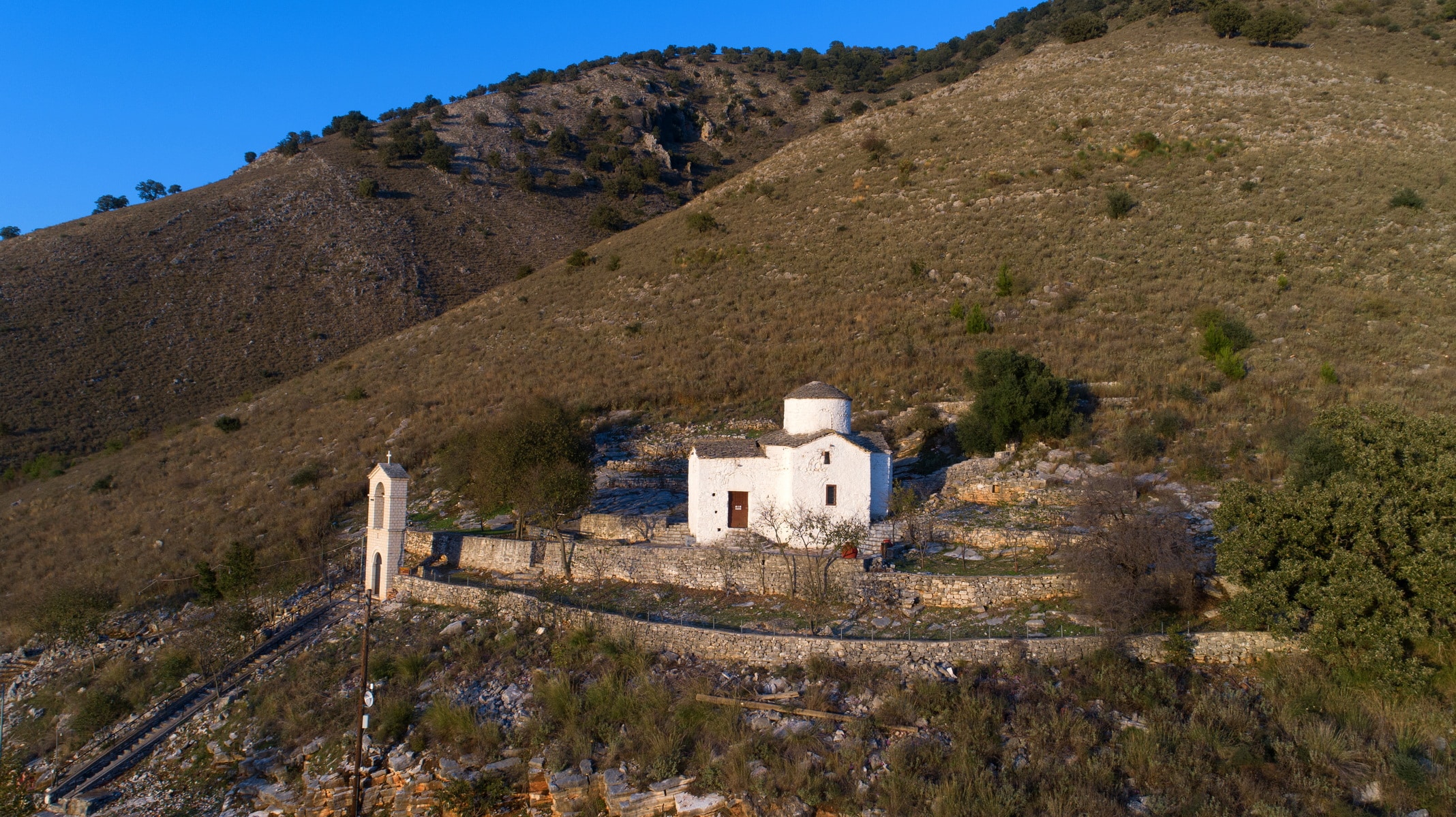
The cave: The cave, impressive for its size and outcrops, has an opening of 4×4 meters and is up to 30 meters deep. The access to the interior is from the church of Agia Paraskevi’s north, where a steep staircase leads to the cave’s underground chamber. The foundations of a building, which was probably a chapel, have been found in this chamber and suggest that the opening was a place of worship from ancient times. According to the inhabitants, water drips from stalactites on the 26th of July, the day of the saint’s feast, on a well next to the remains. There is an elongated area in the right part of the cave that remains unexplored.
History – Studies: There are no written testimonies about the temple and the cave. In the years of the revolution of 1821, the church was set on fire. Parts of the wall and the dome were rebuilt in the last century. The monument’s architecture was first studied by the archaeologist, P. Vokotopoulos, who dated the church to the second half of the 11th century according to its morphological data.
Architecture: The church, dimensions 10.85×6.70m, belongs to the type of free cross. It has a tall, cylindrical dome and a square narthex to the west that extends the vertical antenna of the cross. To the east, it ends in a semicircular arch.
Five entrances led to the church. There were two in the main temple, on the north and south side, and one on the three sides of the narthex (north, south, and west). Today only the entrances from the north and west side of the narthex are in use, and the rest have been built. The oldest church of St. Vasilios of the Bridge belongs to the same architectural type.
Exterior decoration: The masonry consists of irregular stones and the roof of gray slate. The exterior decoration consists of a serrated band defining the drum’s perimeter and the dome’s windows. The same band seems to have circled the entire monument, as evidenced by the remains on the temple walls.
Interior decoration: The church is covered by arches in the interior, while four niches are formed in the thickness of the wall on the north and south side (transverse antenna of the cross). The wall surfaces inside are plastered, without frescoes, while the wooden iconostasis was placed probably in the 19th century.
Despite the lack of painted decoration, the monument is of great interest belonging to the mid-Byzantine period. Along with the churches of Saint Dimitrios Katsouris, Saint Vassilios of the bridge, and Panagia of Koronisia, it is an architectural sample of the period before the Despotate of Epirus’ foundation.
The Church of Agia Paraskevi of the dragon has been designated as a historical monument.
Small Theater of Ambracia
And in Amvrakia a temple of the same goddess (Afrodite) and a hero-shrine of Aeneas near the small theater. In this shrine there was a small archaic statue of wood, said to be of Aeneas”
Dionysios of Alikarnassos, Roman Archeology 1.50.4.
The Dionysios of Alikarnassos’ testimony of the 2nd century AD about the existence and location of the small theater of Amvrakia was an important source for its identification.
Survey: The theater was first excavated in 1976 after a few months of research on St. Constantine street, occasioned by an excavation to construct a new building. Excavation works started again in 2011. They continued within the framework included in the NSRF project “”Works for the Promotion and Shaping of the archaeological site of the Small Theater of ancient Amvrakia”” (2014-2020)
Location: The small theater is the smallest known preserved theater in Greece. It was found near St. Konstantinos church and is part of the administrative and religious center of the ancient city, as evidenced by the adjacent public buildings. The post-archaic church of Apollo on Vasilios Pyrrou Street, the Large Theater on Tsakalov Street, and the Rector’s Office, preserved beneath the square and the church of Agia Theodora, are the most important nearby structures. In addition, buildings of the ancient city and a paved street were detected in the theater’s surrounding area.
Construction: The theater was not built on a natural hill as was customary, but on an embanked slope on the remains of a bath complex with pebble mosaics dating to the middle of the 4th century BC. A robust retaining wall supports and delimits the theater to the east.
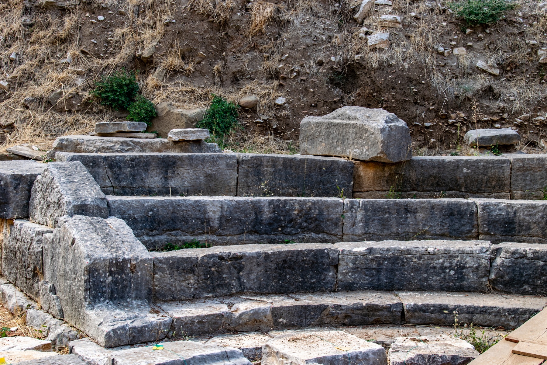
Parts of the theater have been revealed: Part of the koilon (auditorium) and the parodoi (the two entrances between the scene and the seats), the orchestra (the circular area facing the audience), and the western part of the proskenion’s (front side of the scene) pillar.
The koilon, made of good quality limestone, is crossed by two radial staircases that divide it into three sections with five rows of seats, while the existence of another row is very likely. The seats were made of stone, while the absence of the Proedria (the front seats, reserved for officials and priests) is unusual. Three rows of seats are preserved in both side sections and four in the central one.
The orchestra has the shape of a perfect circle, with a diameter of 6.70 m.
The proscenion was a 10 m long stone building. Its facade was probably decorated with six Ionic half-columns, while a slate-roofed rainwater pipe ran over its entire length.
Dating: According to the architectural elements, the small theater was built at the end of the 4th c. – the beginning of the 3rd c. BC, during the reign of Pyrrhus, that is, during the heyday of Amvrakia, when the city became the kingdom’s capital.
The Large Theater: The Large Theater of Amvrakia, as already mentioned, was located nearby. However, it is impossible to be unearthed, and we know few things about it. Its location has been detected beneath the modern buildings of Arta, but unfortunately, its proximity to these structures leaves no room for further exploration.
Western Nekropolis of Ambracia
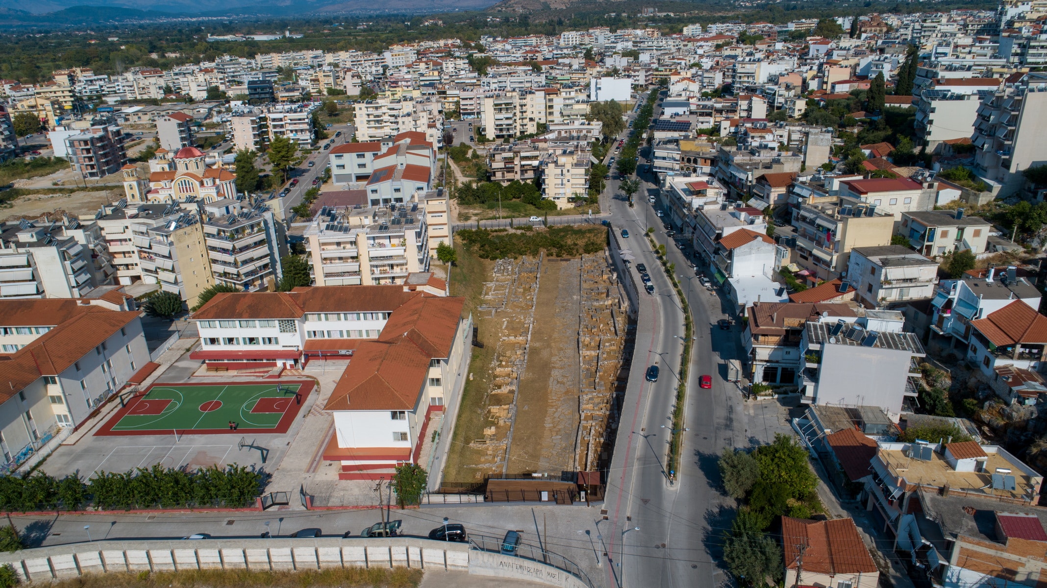
The city: Amvrakia was founded as a colony of the Corinthians in 625 BC. in the fertile plain defined by the northern slopes of the Peranthi hill and the navigable river Arachthos that surrounds it for the most part. The natural fortification was strengthened by its walls, which are estimated to be 4.5 km long. Apart from the land’s abundance, the city held a privileged geographical position, located near the sea of the Amvrakikos and on the only exit of Epirus to the South. Inside the walls, the geometric urban design formed large residential areas, measuring 150×30 meters, separated by wide roads up to 5 meters wide. The public spaces with the market and the temples were developed to the northwest. The ancient city is located beneath the present city of Arta and occupies half of its area.
The western necropolis and the sacred road: The two necropoleis, which were in constant use from the city’s foundation until its decline, stretched outside the Amvrakia walls, on the eastern and western slopes of Peranthi hill. The cemetery to the west that was organized along the sacred streets was larger and more impressive. 12m wide, the burial road was paved or concrete and led from the South Gate to the city’s port in the Amvrakikos Gulf. To date, a part of it, 300m long, has been revealed near the National Stadium.
The sacred street was surrounded by monumental burial enclosures and burials on various levels. The most common burial method was burial in a simple pit or a cist grave made of limestone slabs. Cist graves were often used as family graves, while cremation was common. The urns, where the remains of the cremations ended up, were placed in square burial cases or pits or cist graves. Grave goods accompanied the dead, and the graves were marked with tombstones bearing their names. These inscribed burial columns from domestic limestone are a unique assemblage as Epirus is concerned. Their special feature is the simple decoration, which is limited to branches of ivy, olive, or oak, and the frequent inscription of the patronymic next to the deceased’s name. The nationality, the profession, or the invocation “”ΧΑΙΡΕ”” (be happy in Greek) is rarely mentioned. The tombstones of Amvrakia were made between 500 and 200 BC by local craftsmen.
Polyandrio (today on Kommenou Street): Polyandrio, a cenotaph founded by the city around 600 BC to honor the dead people of Amvrakia and Corinth, who were killed in a battle, is one of the burial monuments. The monumental construction has a length of 12.40m, a width of 8m., and a height greater than 2.40 m. But what makes it unique is the word “”Anprakia”” written on its facade, which is the oldest reference to the city’s name. The inscription is written boustrophedon (a style of writing in which alternate lines of script are reversed) and stoichedon (the letters were aligned vertically and horizontally). The monument’s sanctity remained over the centuries, as it operated as a cemetery with a three-aisled nave during the Byzantine era.
Church of Aghios Maximos ‘the Greek’
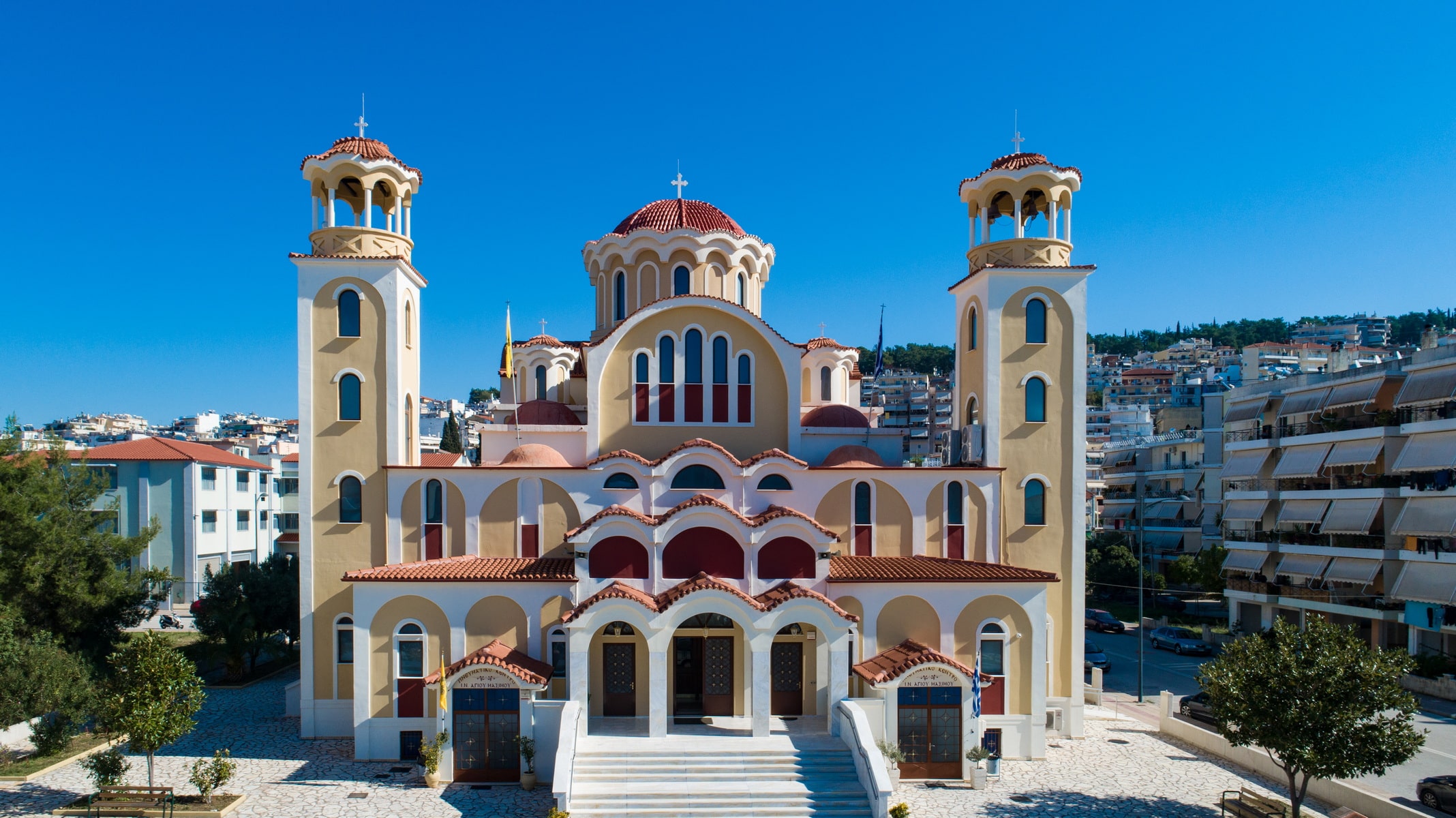
Saint Maxim the Greek Church was inaugurated in June 2016 in the area Trigono of Arta. This is the first church founded in honor of the saint in his birthplace. It is expensive and imposing work, which has not been completed yet, of great importance for the city, as Saint Maxim is one of the greats of the 16th century with a reputation beyond Greece’s narrow borders. He had an enlightened personality, which marked the spiritual life and orthodox theology. Known as Saint Maxim of Vatopedi, he has been described as a “”reformer of the Russians””, while the Russians themselves call him “”Maksim Grek””, meaning Maxim the Greek.
His contemporary, the Russian professor of philosophy, Mikhail Gromov, wrοte about him: “”as a worthy successor of the important Greek civilization, Saint Maxim rightly became a wise philosopher and famous writer of the Russian land, who contributed the most to the development of our culture.”.
His memory is honored on the 21st of January, while the faithful worship his relics, which are kept in the church.
A few words about the life of Saint Maxim of Vatopedi or Greek: Saint Maxim, the world-famous Michael Trivolis was born in Arta in 1470 AD, where his father, Manuel, from Sparta-Mystras, had settled. His mother was called Irene. Saint Maxim’s parents were of noble origin and highly educated. Russian sources describe them as “”philosophers”” revealing a higher education, while the saint himself describes them as “”genuine believers””.
Little Michael first learned next to his parents and, at a young age, traveled to Corfu, to the scholar Dimitrios Trivolis, his father’s brother. There, he continued his education with the philosopher Ioannis Moschos, who was a student of Georgios Plithonas Gemistos and completed his studies in Italy. He studied at the Greek school in Venice and later at the Universities of Padua, Florence, and Milan, where he had prominent Greek teachers, such as Ianos Laskaris, Laonikos Chalkokondylis, and others.
He became a monk in 1505-6 on Mount Athos and received the name Maxim. The rest of his life will find him in Russia, where he went at the invitation of the Tsar, Vassily Ivanovich, in 1516. His mission was to translate various liturgical and theological books into Slavonic. For 17 months, he was successfully translating the books. However, his stay in the country took a dramatic turn after the defamatory accusations of heresy and magic unleashed against him by Daniel, the abbot of the Volokalamsk Monastery. Maxim was imprisoned for many years and endured shackles, torture, and exile. Finally, in 1551, he was transferred to the Lavra of St. Sergius, where the abbot surrounded him with a lot of love, appreciating his spiritual work. There, he left his last breath on the 21st of January, 1556.
Saint Maximus wrote many apologetic and interpretive works. He was canonized on the 31st of May, 1988.
An Orthodox Theological Institute was established in Athens to honor the saint, encouraging research, recording, preservation, dissemination, promotion and projection of the wealth and reserves of global Orthodox spirituality and culture: “”Saint Maxim the Greek Institute, Research, Preservation and Promotionof Spiritual and Cultural traditions””.