

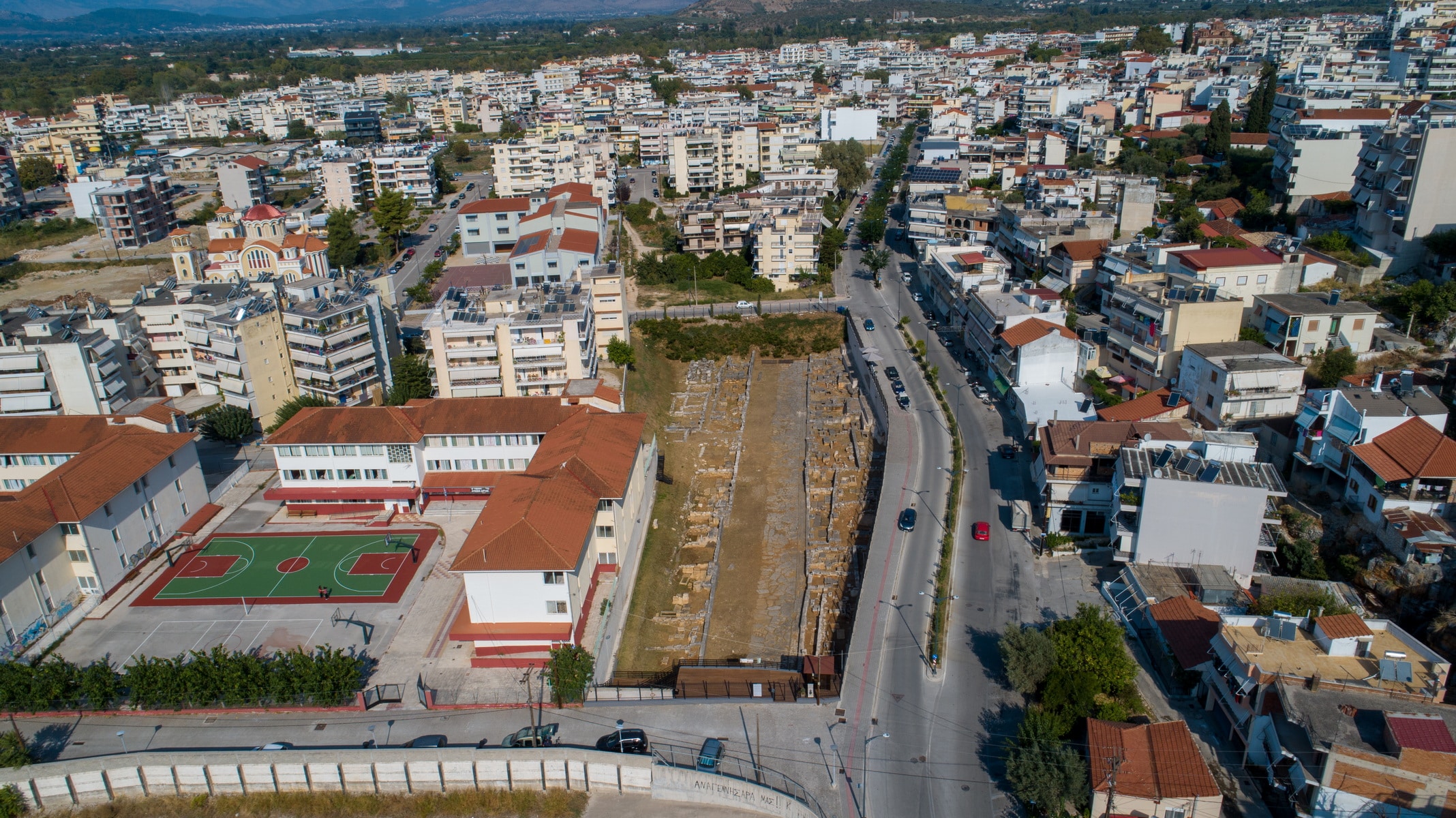
The city: Amvrakia was founded as a colony of the Corinthians in 625 BC. in the fertile plain defined by the northern slopes of the Peranthi hill and the navigable river Arachthos that surrounds it for the most part. The natural fortification was strengthened by its walls, which are estimated to be 4.5 km long. Apart from the land’s abundance, the city held a privileged geographical position, located near the sea of the Amvrakikos and on the only exit of Epirus to the South. Inside the walls, the geometric urban design formed large residential areas, measuring 150×30 meters, separated by wide roads up to 5 meters wide. The public spaces with the market and the temples were developed to the northwest. The ancient city is located beneath the present city of Arta and occupies half of its area.
The western necropolis and the sacred road: The two necropoleis, which were in constant use from the city’s foundation until its decline, stretched outside the Amvrakia walls, on the eastern and western slopes of Peranthi hill. The cemetery to the west that was organized along the sacred streets was larger and more impressive. 12m wide, the burial road was paved or concrete and led from the South Gate to the city’s port in the Amvrakikos Gulf. To date, a part of it, 300m long, has been revealed near the National Stadium.
The sacred street was surrounded by monumental burial enclosures and burials on various levels. The most common burial method was burial in a simple pit or a cist grave made of limestone slabs. Cist graves were often used as family graves, while cremation was common. The urns, where the remains of the cremations ended up, were placed in square burial cases or pits or cist graves. Grave goods accompanied the dead, and the graves were marked with tombstones bearing their names. These inscribed burial columns from domestic limestone are a unique assemblage as Epirus is concerned. Their special feature is the simple decoration, which is limited to branches of ivy, olive, or oak, and the frequent inscription of the patronymic next to the deceased’s name. The nationality, the profession, or the invocation “”ΧΑΙΡΕ”” (be happy in Greek) is rarely mentioned. The tombstones of Amvrakia were made between 500 and 200 BC by local craftsmen.
Polyandrio (today on Kommenou Street): Polyandrio, a cenotaph founded by the city around 600 BC to honor the dead people of Amvrakia and Corinth, who were killed in a battle, is one of the burial monuments. The monumental construction has a length of 12.40m, a width of 8m., and a height greater than 2.40 m. But what makes it unique is the word “”Anprakia”” written on its facade, which is the oldest reference to the city’s name. The inscription is written boustrophedon (a style of writing in which alternate lines of script are reversed) and stoichedon (the letters were aligned vertically and horizontally). The monument’s sanctity remained over the centuries, as it operated as a cemetery with a three-aisled nave during the Byzantine era.
All destinations
Church of Panaghia of “Vlacherna”
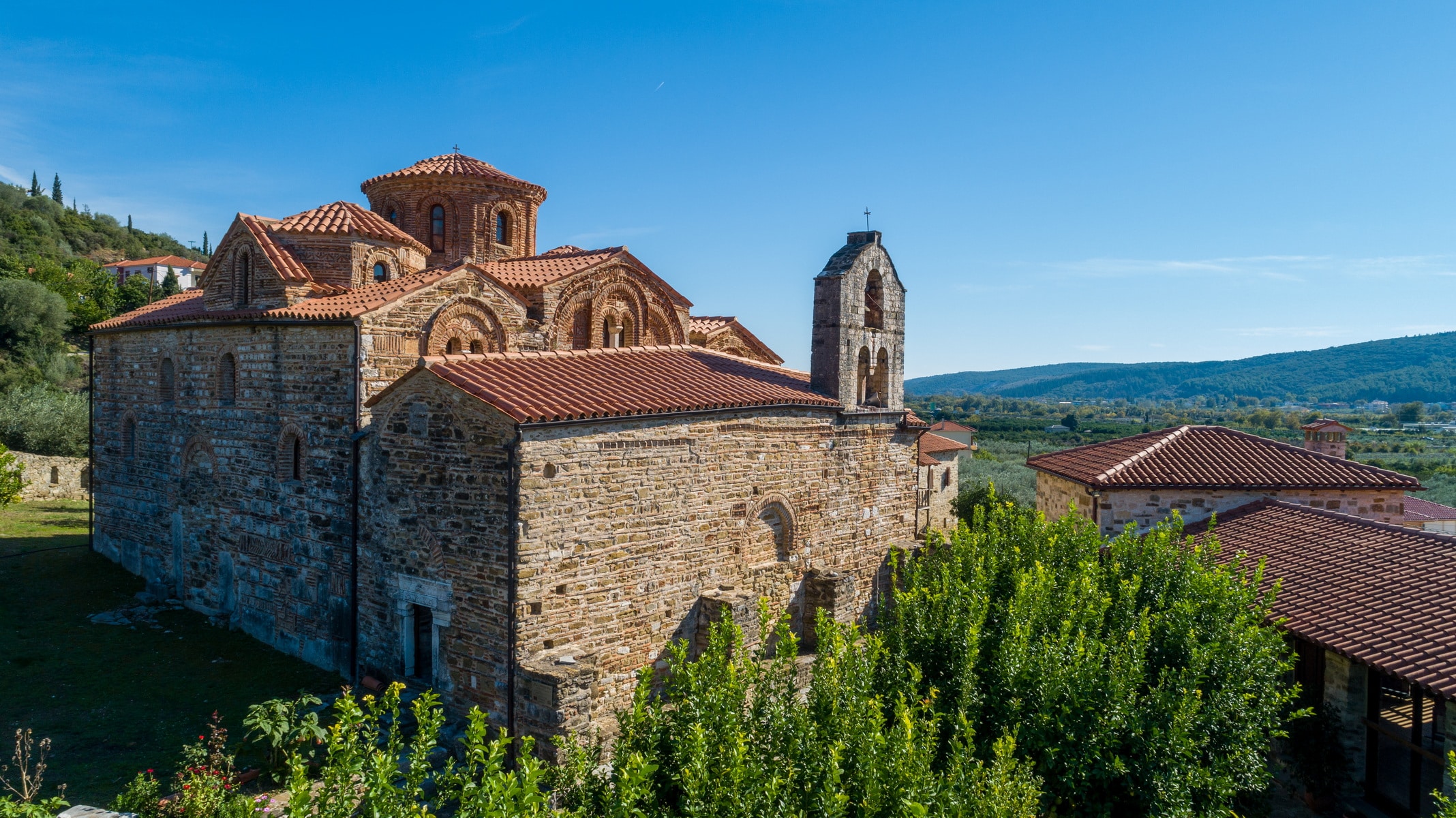
Virgin Mary of Vlacherna church, whose name is associated with the well-known Virgin Mary of Vlacherna temple in Istanbul, is located in the homonymous village, about 1 km northeast of Arta, on the other bank of river Arachthos. It is classified as one of the important monuments located around Byzantine Arta, such as Kato Panagia, Panagia of Koronisia, Pantanassa near Filippiada, the church of Panagia Brionis in Neochoraki, etc.
It is a three-aisled vaulted basilica with rich sculptural and painted decoration. Vlacherna was the katholikon (central church building) of the famous monastery and burial temple of many members of the Komnenodoukades, rulers of the Despotate of Epirus. The inscriptions preserved on two graves on the south and north wall of the main church reveal that the first belonged to the despot Michael II Komnenos Doukas, the illegitimate son of Michael I Angelos, founder of the Despotate. The second belonged to the sons of Theodora Komninodoukaina (Saint Theodora), who had a violent death.
The initially men’s monastery became a women’s monastery, as attested by a synodal letter of the Metropolitan of Nafpaktos, Ioannis Apokafkos (1224-1230), the first written reference to Vlacherna.
Architecture – dating: The katholikon was built on the site of an older church dating to the late 9th to early 10th century. The initial church was probably a three-aisled basilica with a three-part sanctuary and a wooden roof, parts of which are the south wall (the difference can be seen in the masonry) and the south arch. Virgin Mary Vlacherna church, a three-aisled basilica with an arched aisle, was probably founded at the beginning of the 13th century (between 1224 and 1230). In the middle of the same century, it is estimated that the vaulted basilica was altered into a domed one with the construction of three domes, one central and two smaller at the sides. At the same time, a curved dome was added to the northern aisle. The arches that house the aisles are covered externally by double roofs that form pediments.
The entrance to the original temple was made by five door openings, one on the north and south side and three on the west. Today the main gate on the west side remains open, while the side openings have been turned into windows.
The church’s narthex whose floor has a great difference in height from the main church has a later date (around the end of the 13th century). The oldest floor of the katholikon is decorated with marble slabs in colorful marble frames. In the center of the middle aisle, five interlocking circles, decorated with mosaic decoration, give the symbolic depiction of the five loaves. The central circle is decorated with a mosaic representation of a double-headed eagle.
Sculptural decoration: The temple is decorated externally on the east side and pediments with brick decorative themes. There are architectural reliefs inside the church, mostly capitals of reused columns that originate from early Christian or ancient buildings. The sculptural decoration includes a marble slab that closes today the window on the south side and depicts a relief form of the archangel Michael.
Several sections of the marble iconostasis are preserved, many of which are walled into the temple’s entrances. A reconstruction attempt of the iconostasis lies at the sculpture room in the dining room of Parigoritissa. The Vlacherna iconostasis is considered one of the masterpieces of Late Byzantine sculpture for its excellent carving and the abundance of decorative themes.
Frescoes: The painted decoration of the monastery’s katholikon was revealed during the removal of newer plaster in 1975-1977. The evident stylistic differences have led to the identification of two phases consistent with the temple’s construction interventions.
The frescoes of the main church belong to the first phase and date back to the middle of the 13th century. Some of the representations are The Visitation of Mary to Elizabeth, The holy Myrrh-bearers, Scenes from the Passion of Christ, and The Incredulity of Saint Thomas .
The frescoes of the narthex belong to the second phase. The most important representations are the Second Coming, the Troparion of Christmas, and the litany of the image of the Hodegetria.
Although the iconographic program has not been brought to light entirely, it is enough to reveal the monumental style and art of high artistic demands. The use of the semi-precious stone, lazurite (lapis lazuli), to give the blue color to the tents’ background and the figures’ clothes is indicative. The quality and craftsmanship of Vlacherna murals’ art equal the artistic expression of Constantinople and Thessaloniki.
Dedication of the temple: The temple used to be dedicated to the Assumption of the Virgin until 1814. Today, the temple, parish church of Vlacherna village, is dedicated to the Laying of Our Lady’s Holy Robe and celebrated on the 2nd of July.
Castle of Arta
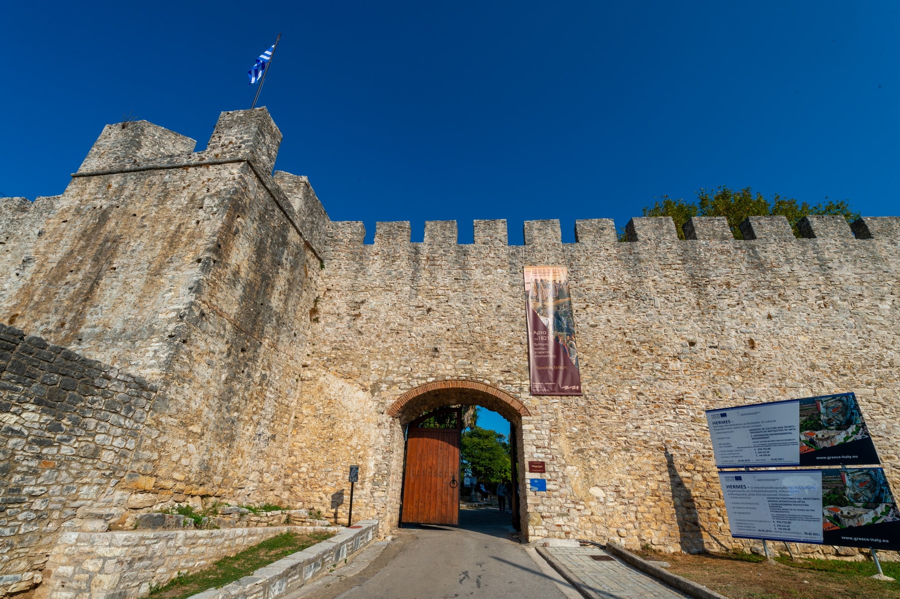
The castle: The Byzantine castle of Arta occupies a hill on the northeastern side of the city and incorporates parts of the ancient fortification of Amvrakia. The strategic importance of the place was acknowledged by the ancient Amvrakiotes, who included it in the strong fortification of the lower city following the northern turn of the Arachthos River. The walls’ lower part with the colossal carved stones can be seen on the east and north sides of the Byzantine castle, which is supported on foundations and part of its superstructure.
According to the prevailing standpoint, the ancient fortification was, during the mid-Byzantine years, preserved at a sufficient height, which defined the city and protected the inhabitants. Although we know neither the extent of the Byzantine city nor the actual defensive effectiveness of the ancient walls, their presence seems to be a fundamental reason that the Byzantine castle is relatively small. It did not surround the whole city in contrast to other cities of the time, such as Ioannina, Mystras, Monemvasia, Rogoi, etc. . It was the administrative and military center and seat of the rulers of the Despotate, while the inhabitants resorted to it only in case of need.
According to newer data, the castle of Arta dates back to the mid-Byzantine period. Together with the ancient fortification, it contributed dynamically to the urban development of the Byzantine city, constituting a typical example of Byzantine fortification art and an impressive remnant of medieval Arta. Over the centuries, it has undergone renovations, additions, and repairs.
It consists of three parts:
1) the main fortress
2) two small external walls built at a lower level
3) the inner Acropolis fort, located to the left of the main gate
Its shape is an irregular polygon (maximum length 280m., width 175m.) that is interrupted every 25m. from semicircular, triangular, or polygonal towers, except for the eastern part, which is supported on the ancient wall. It is 2.50 meters thick. Its height reaches 10 meters and is crowned with ramparts having a wall walk for the defenders. Its masonry is simple, with irregularly carved small stones and brick insertion, covered later with mortar. More elaborate, isodomic, cloisonné Byzantine masonry system is found in the upper part of the castle’s west side, while on the east side of the inner fort, there is also brick decoration.
The Chronicle of the Tocco (14th-15th century) states that outside the castle gate was the market “”Borion”” or “”Emporion”” surrounded by houses and gardens. It must have extended along the main road leading to the castle. That is why this area attracted Jews early on (12th century), who settled there and gave the district the name Evraika, which means Jewish.
During the Ottoman period, the castle lost its importance and served as a prison for a long time. General Makrygiannis was imprisoned there.
Xenia: Arta’s old XENIA hotel, the most important and talked-about building in the Prefecture, lies in a central place inside the castle. A modern building in its time, it was built in 1958 by Dionysis Zivas, an architect and professor of the National Technical University of Athens, and funded by the Hellenic Tourism Organization.
The hotel offered just 20 sleeping rooms, while large event venues filled the rest of the place. It closed permanently in 1992.
After years of abandonment that made the building almost inaccessible, an architectural proposal was submitted in 2020 (Xenia 2020) to repurpose Arta’s XENIA. The proposal aims to fully utilize the building and the surrounding area to host various cultural, entertaining, educational, and recreational activities.
Finally, various cultural events are organized every summer in an area inside the castle.
Church of Aghia Theodora
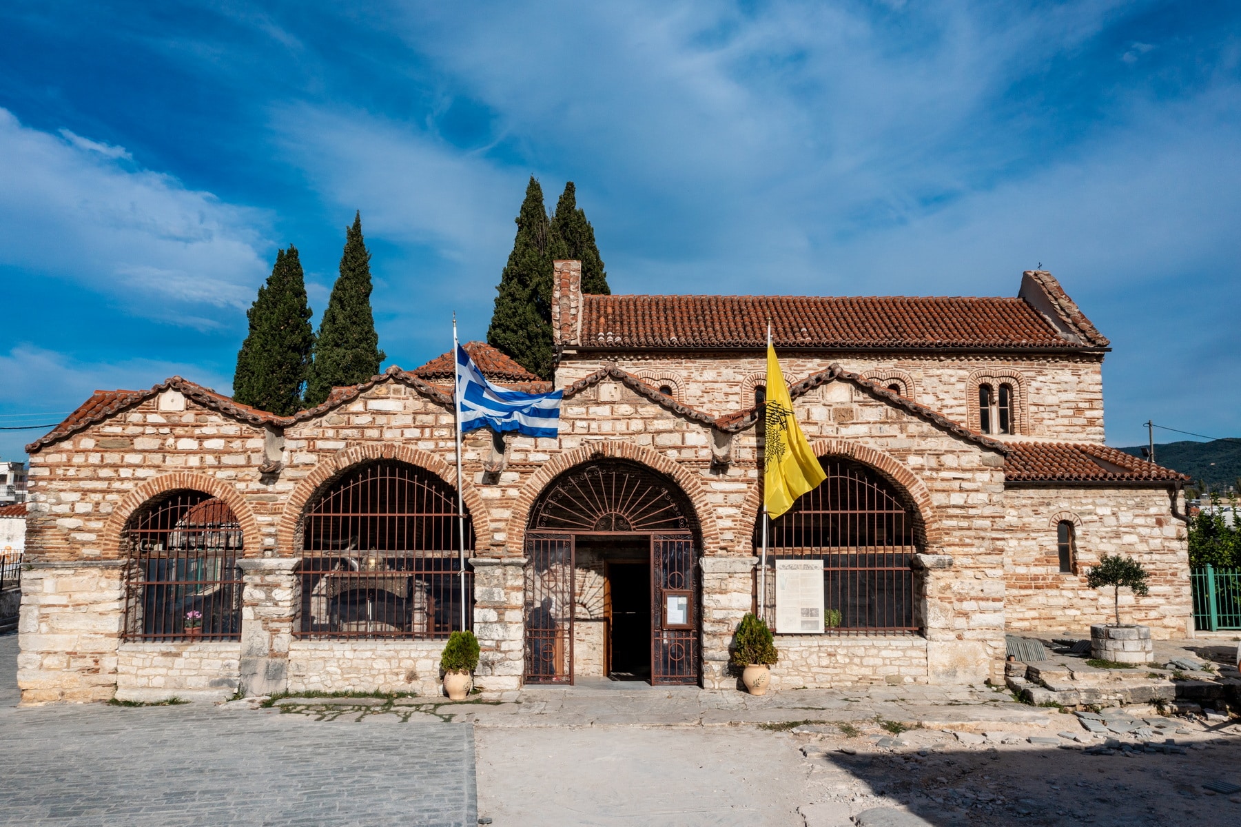
The church of Agia Theodora is located in the center of Arta, at the shortcut of Vassileos Pyrrou Street. The area used to be the bustling center of the Byzantine capital, in the lower city district.
It is one of Arta’s most important monuments, not only for its morphology but mainly because this church is like a living connection of the present city with its Byzantine past since it is dedicated to its queen, the city’s Saint Theodora. The church has a special emotional bond for the people of Arta, connecting them to their past as a secret link, an inner communication with the creators, the Despotate’s people, and its symbols. This connection becomes apparent to the visitor as the monument opens an imaginary window to the greatness of the Despotate.
Written reports-studies: Written testimonies about the temple during the Byzantine period come from the monk Job Melias (13th century), a contemporary of the ruler Michael II Komnenos Doukas and biographer of Saint Theodora, the despot’s wife. The monument again is referred to in textual 17th-century testimonies by the Turkish traveler Evliya Celebi, who reports that the church had such an abundance of dedications from all over Francia, that the Turkish authorities collected money for protection. Two hundred priests served in the church and offered food and shelter to passers-by.
The church was systematically studied and published by Anastasios Orlandos in 1936, while an extensive study by G. Millet had preceded it. G. Lampakis and the Archimandrite Antonios, who made the first sketches at the end of the 19th century, had previously studied the monument.
History and dating: The church’s construction dates back to the mid-Byzantine years before the founding of the Despotate. It was the monastery’s katholikon (central church building) dedicated to Saint George. It dates back to the middle of the 12th century or, according to others, to the end of the 11th. It is built on the ancient Amvrakia’s rectorate as a recent (2019) excavation of the Ephorate of Antiquities revealed. It was a women’s monastic community. Queen Theodora lived in the monastery during the last years of her life, after first becoming a nun and renovating the katholikon that was dedicated to her memory after she was canonized. Today, the church is dedicated to St. Theodora, the patron saint of Arta, celebrated on the 11th of March.
A few words about the life of Saint Theodora: Theodora was the wife of Despot Michael II Komnenos Duke, the illegitimate son of the founder of the Despotate of Epirus Michael I Komnenos, from the Angelos family. She was the daughter of the sevastokrator Ioannis Petraleifas, of Norman-Italian descent. Her family was one of the Hellenized branches of the descendants of Peter, son or brother of the lord Alifa, in Caserta, Italy, who settled in Byzantine territory, fighting on the side of the emperor Alexios I Komnenos. Michael II met her in Serbia, where she lived with her family. According to her biographer, Theodora was exiled a few years after her marriage because the ruler became interested in another woman, a noblewoman from Arta, and generally led a dissolute lifestyle. Unable to tolerate her husband’s behavior, she wandered in the countryside, where she lived in absolute poverty. According to her biographer, she was found by a priest in a state of absolute poverty, gathering potherbs. He revealed her identity to him, who took her under his protection in Prenista village (today Korfovouni of Arta), where he was a priest. After five years of exile and under pressure the people of Arta exerted on the ruler, Theodora was restored. Arta’s inhabitants, with the support of the nobles, revolted against Michael II, outraged by the disorderly life he led and his behavior towards his wife. The despot brought Theodora back to her royal position and founded the monastery of Kato Panagia and Panagia Pantanassa, near Filippiada, as a sign of sincere repentance.
Theodora Petraleifa was an important personality and played a crucial role in the political affairs of the Despotate. She made a significant contribution to signing the peace treaty of the Despotate of Epirus with the Empire of Nicaea. Under the pretext of her son Nikiforos’ marriage with the daughter of Theodore II Laskaris, Emperor of Nicaea, she visited the city twice, leading the negotiations and achieving the peaceful coexistence of two traditional enemies for a short period.
The witty Theodora went down in history for her philanthropic work. She became a nun after her husband’s death and retired to the monastery of St. George until the end of her life. When she died, she was buried in the monastery’s katholikon, which was later dedicated to her name. The inhabitants never ceased being associated with her and declared her the city’s patron saint.
Architecture:
Phase A: The Katholikon is a typical wooden-roofed basilica and belongs to the first construction phase of the monument. Its eastern wall ends in three broad, three-sided arches. The three-part sanctuary has two transverse walls with door openings that separate the Chancel from the Prothesis and the deaconry. In the interior, the main church is divided into three aisles defined by colonnades. The central aisle stands higher than the side aisles and is housed with a pitched roof. The side aisles have single-pitched roofs and eight bifora windows.
Two more construction phases follow.
Phase B: The most basic phase dates back to the glorious period of the Despotate around 1270, when Queen Theodora renovated the church. It was then that the three-part vaulted narthex was added to the west. There is a low dome in the roof’s center. It has three entrances, west north and south, and three inner gate openings to communicate with the main temple. Today, the southern opening is blocked by the tomb of St. Theodora. Three pediments are formed on the exterior west side. The central one has a bifora window and rises in front of the low dome. This peculiarity is also observed in the katholikon of the monastery of Vlacherna, which dates back to the same period.
The addition of two large, pointed pediments to the east and west walls of the central aisle probably belongs to the same construction phase. The pediments project above the roof level and each has a bifora window.
The pointed gate, located a short distance south of the church with the characteristic, rich ceramic decoration of the period, is also a work of the 13th-century.
Phase C: The next and last phase dates back to the end of the 13th and the beginning of the 14th century. It includes the addition of an open entrance, in the shape of a Π, surrounding the west side of the narthex and parts of the north and south sides of the katholikon. Today, only the southwest corner and its south side (supported by pillars) survive.
The 2019 excavation revealed several elements of the gallery and the temple’s surrounding area.
Masonry-exterior decoration: The masonry of the temple consists of irregular stones with bricks placed in between in a horizontal, irregular arrangement. In contrast to the simple walls of the katholikon, indicative of its early dating, the high pediments of the central aisle present an intense ceramic decoration that fills the masonry and surrounds the bifora windows. Jagged decorative bands, successive plinths, and adornments made of broken vessels are some examples of this dense embellishment. Many zones of ceramic decoration also surround the masonry of the narthex, dated at the same time (13th century). Some are bands with crosses, suns and meanders, zigzag lines, and lattice patterns.
Church of Aghios Vassilios
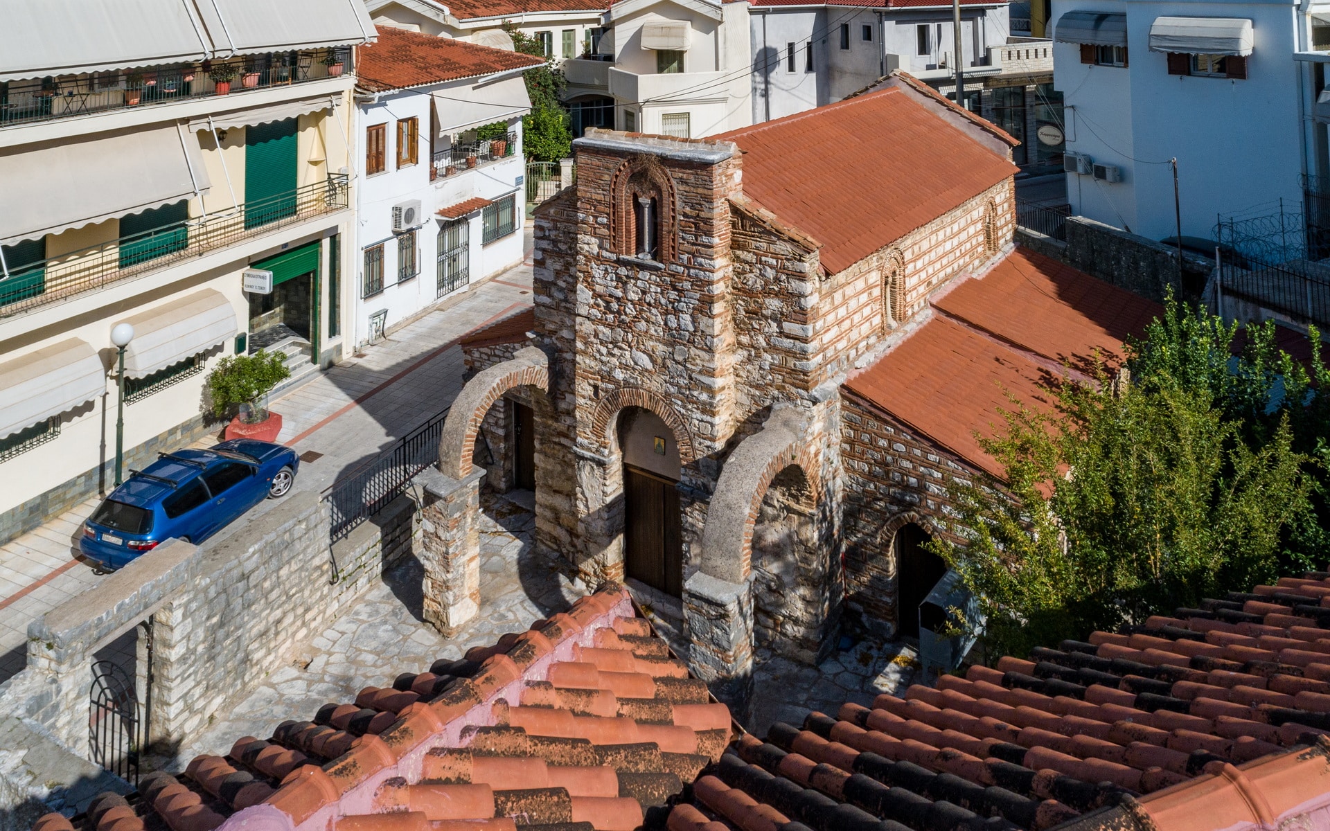
Saint Vassilios Church, located in Arta, Greece, is a significant Byzantine monument. Situated in the bustling market district, it stands just north of Aghia Theodora church. Notably nicknamed “tis agoras” (of the market in Greek), it distinguishes itself from the nearby church of Saint Vassilios “tis gefiras” (of the bridge in Greek).
In 1662, the Manolaki school, a renowned Greek educational institution, was established within the church premises. Named after its founder, Filippos Manolakis, a prominent Kastorian fur merchant, this school flourished under the patronage of Nektarios, Patriarch of Jerusalem. Despite its illustrious history, tragedy struck in 1821 when the church succumbed to fire. Noteworthy scholars of the time, including Sofronios Leichoudis, Paisios Metaxas, and Gerasimos Palladas, served as faculty members.
The church underwent a meticulous study and restoration in 1936 under the guidance of A. Orlandos.
Dating back to the late 13th century, the architecture of Saint Vassilios Church bears striking similarities to contemporaneous Byzantine monuments. Originally constructed as a single-room, wooden-roofed basilica, it underwent expansion around 1300, with additional wings housing chapels dedicated to Saints Chrysostom and Gregory. This expansion transformed the structure into a three-part division, characterized by a unique three-sided arch and protruding east pediment and west wall.
The exterior of the church boasts Byzantine cloisonné masonry, adorned with intricate ceramic decorations, particularly on the east and north sides. Noteworthy among these decorations are 14th-century AD glazed clay icons depicting religious scenes.
Sculptural adornments within the church are limited, with Corinthian capitals adorning colonnades and a reused marble capital featuring a relief cross and thorn leaves.
Internally, the church features a rich iconographic program, depicting various religious scenes and saints. Despite suffering damage, the frescoes within the church display a preference for naturalistic traits and realistic facial features, reflecting Western artistic influences.
Saint Vassilios Church stands as a testament to Byzantine art and architecture, attracting visitors and scholars alike with its rich history and cultural significance.
Church of Aghia Paraskevi
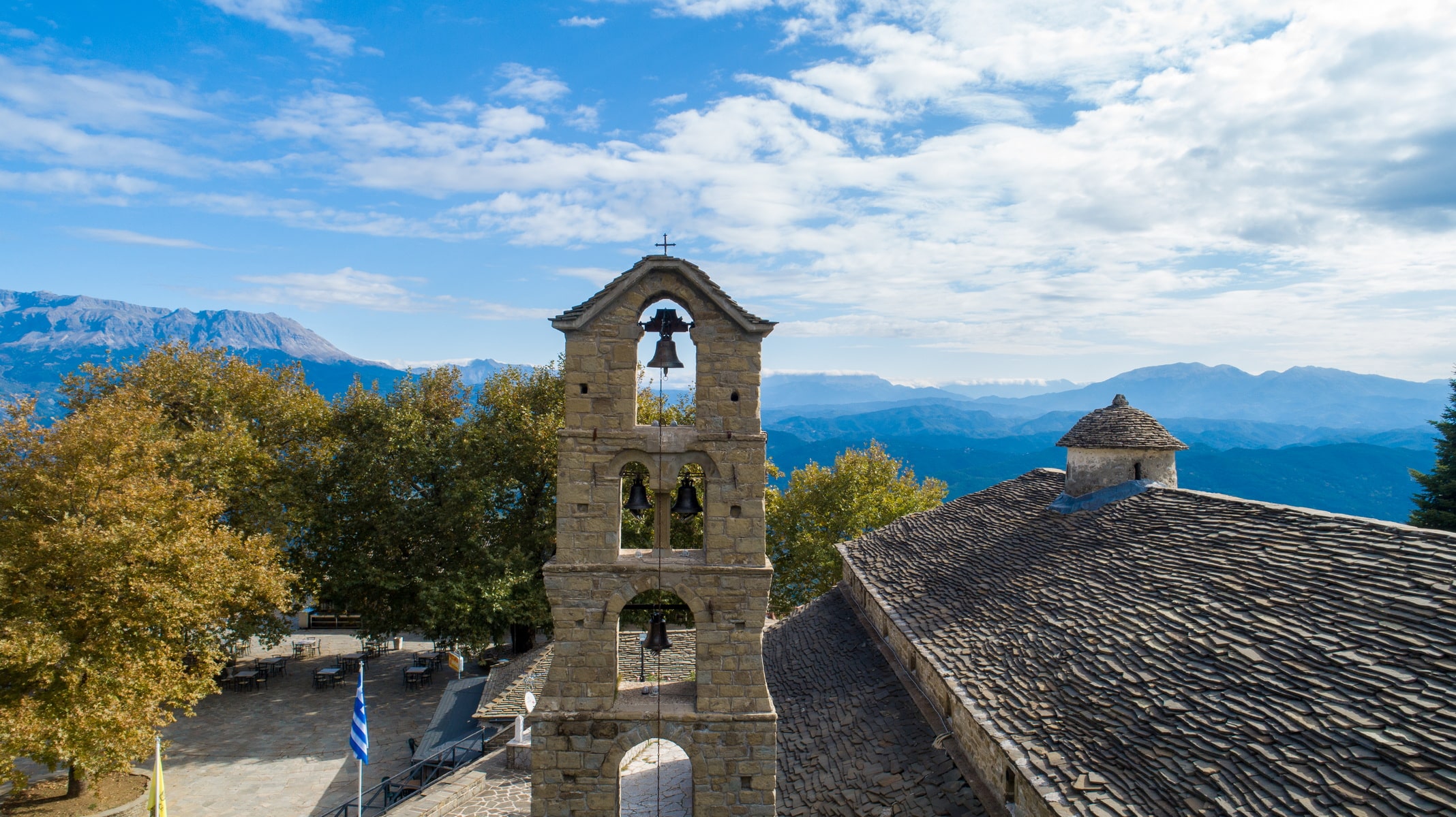
Saint Paraskevi church lies on a low hill in the center of Rodavgi, 24 km north of Arta. According to local tradition, the inhabitants built the temple at that specific place at the suggestion of the Saint herself, when after a powerful landslide, they left their initial village and settled in this area. The old village is mentioned as Agia Paraskevi, Chavos, and Kakolagado, names that testify both the unfavorable geological position and the existence of Saint Paraskevi church, which relocated to Rodavgi along with the inhabitants. It is said that the Saint’s image was found in the site of the present temple, a theme often met in folklore tradition. The history around the foundation of the church of Rodavgi inextricably links it with the inhabitants’ religious feeling and renders it an important pilgrimage of the wider area.
The bell tower and the old ossuary belong to the church. A cemetery lies to the south of the church, operating up until recently, and two priests’ graves are located to the east, on both sides of the sanctuary.
Architecture: Agia Paraskevi church in Rodavgi was built in 1804, according to an inscription on the lintel of the northern entrance, and follows the mainland criteria of church construction. Made of gray limestone and covered with gray slates, it is classified in the well-known type of three-aisled vaulted basilica with a dome. This type is standard, with variations, throughout Epirus in the 18th century, bringing about apparent changes in ecclesiastical architecture. The absence of complexity in the architectural volumes, the large dimensions, the sturdy construction, the type of the basilica, as well as the heavy slate roofs give the monument solidness and majesty.
An elevated narthex develops along the west side of the temple. The north and west sides are surrounded by a Γ shaped portico with paved floor and benches, while from the same sides, we enter the main church and the narthex, respectively. The portico’s roof, also covered with gray slate, leans on the temple walls and is based on visible wooden beams and modular columns.
The tall bell tower with successive arched openings is also impressive. According to oral testimony, the bell tower was not built during the church’s foundation but in 1850, after the inhabitants funded it.
A wide staircase to the north connects the church with the village square, placing it thus essentially in the settlement’s life and various events.
Exterior decoration: Above the inscription of the north lintel that refers to the year of the church’s foundation, there is a plaque with an embossed anthem. A slit opens between the decorative motif and the inscription, possibly to place the entrance key. Another marble slab lies above the entrance of the narthex with a relief representation of lions, a cypress, and two suns, as well as the year 1863.
Interior decoration: The main church is lower than the narthex, and small domes are located on the roof in addition to the raised dome. Two colonnades, with six stone, Doric columns each, separate the aisles of the temple. The walls are whitewashed. There are just two frescoes in the Chancel depicting the Extreme Humiliation and figures of saints.
The wood-carved baroque iconostasis of the church is of artistic interest. There are decorative bands with parapets and waves, decorated with relief geometric and floral patterns, lion heads, and angel forms. The large images of the iconostasis are supported on a band with parapets separated by colonnades. Above the images, two decorative zones have been formed. Frames for the small images of the architrave have been created above. Carved angels stand out on the top of each image. The iconostasis is crowned with abundant floral decoration, among which two scaly dragons dominate, symbols of the victory of life against death and good against evil. The Crucifixion is depicted on top of the iconostasis with the Virgin Mary and Ioannis images to the right and left.
A unique style is added to the iconostasis by the frontal figure of Christ as the High Priest bearing the bishop’s insignia on the sliding door of the Great Gate. The style and colors are linked harmoniously with the rest of the decoration. Towards the end of the 20th century, the image was removed for an unknown reason. It was replaced by another wood carving, made in a modern workshop. In March 2014, the image, obviously damaged by the abandonment in a warehouse, was restored after the actions taken by people worried for its fate and the care of the parish priest Athanasios Athanasiou. The smaller wooden doors of the iconostasis date to the end of the last century and depict the figures of the archangels Michael and Gabriel. They have replaced the simple, dark red fabric curtains that had a cross and golden fringes.
The Law 3615 / 16-7-1928, F.E.K. 120 / 11-7-1928, vol. A’5 has turned Saint Paraskevi church in Rodavgi into a parish church, which operates as such until today.
The Polyandrion of Ambracia
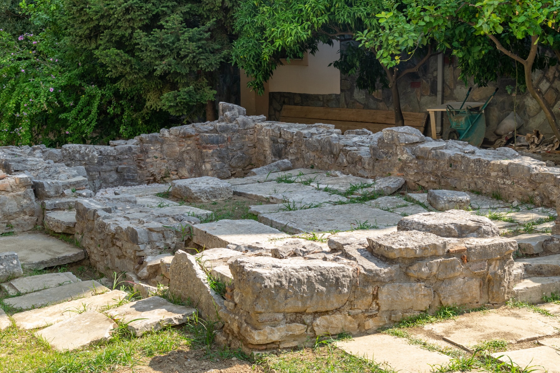
Polyandrio (in Kommenou Street): Polyandrio, a public memorial dedicated to the dead of a naval battle at the mouth of the Acheron river in the late 7th century, is located in the most important and well-organized western necropolis of Amvrakia.
The cenotaph dates back to around 600 BC. and lies on the east side of the necropolis, a short distance from the wall’s gate. It has a Π shape, a highly elaborate construction of monumental dimensions. The facade, 12.40 m long and 2.50 m high, consists of a base and a superstructure with five rows of stones. The second and fifth rows protrude, forming an undulation that continues to the sides for a total length of 8m. The maximum height of the monument is 2.50 m., while at the top of the facade, the upper row of stones has an engraved inscription. The inscription, written boustrophedon (a style of writing in which alternate lines of script are reversed) and stoichedon (the letters were aligned vertically and horizontally) in the archaic Corinthian alphabet, is an elegiac epigram, referring to the city’s public mourning for its dead heroes. It is the only known testimony to date concerning the typical behavior of the people of Amvrakia. In addition, the lyrics of the inscription are of particular interest, as they preserve the oldest reference to the city’s name: “”Anprakia””.
The monument’s sanctity remained over the centuries, as it operated as a cemetery with a three-aisled nave during the Byzantine era.
Holy Monastery of “Kato Panaghia” (The nativity of Mary)
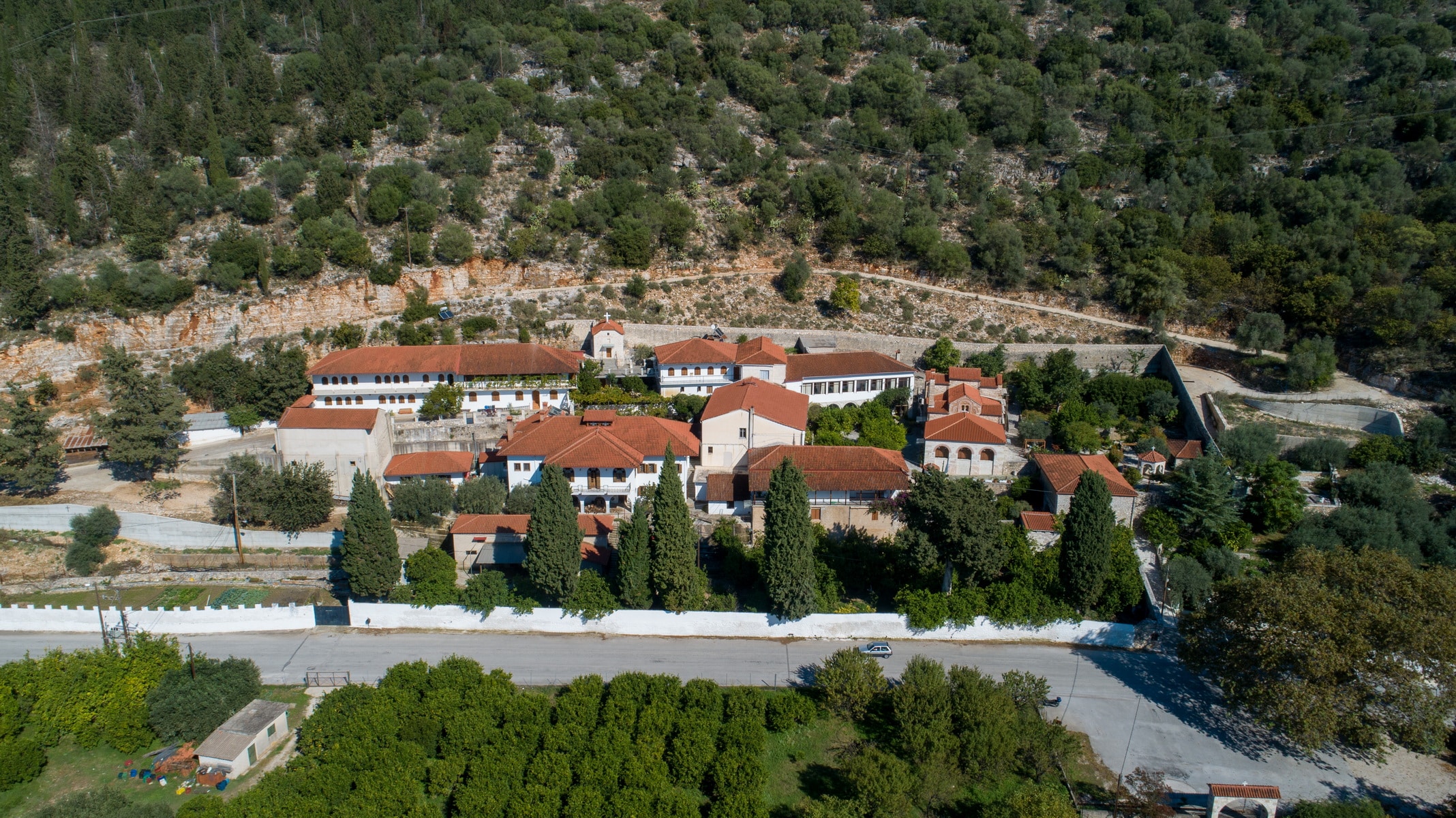
The Kato Panagia monastery, on the bank of the Arachthos river, lies at an altitude of 40m, at the foot of the hill Peranthi, south of Arta, on the provincial road of Arta-Kommeno that leads to the villages.
Dedicated to the Nativity of the Virgin, it received the nickname “”Kato Panagia”” in recent years, probably distinguished from the church of Panagia Parigoritissa that dominates the city’s highest point. Older sources also referred to it as “”the Monastery on the way to the water fountain”” during the Ottoman period.
Foundation – dating-historical reports: It was built in the middle of the 13th century by the despot Michael II Komnenos Doukas, according to the oldest document, written by the monk Job Melias, a contemporary of the ruler and biographer of St. Theodora. According to the same written source, Michael II Doukas founded the monastery, together with the Virgin Mary Pantanassa monastery, as a sign of remorse for the adultery he committed and the exile of his wife, Theodora. The latter became later a saint and is now the patron saint of Arta. The despot Michael II is indicated as the Ktetor (founder) of the monastery by subsequent memoirs (short texts by anonymous authors referring to chronologies and important events) and a later inscription on the lintel of the northern entrance.
According to historical testimonies, the Nativity of the Virgin monastery’s foundation coincided with the Despotate of Epirus’ heyday and operated continuously over time. Seraphim Xenopoulos, Metropolitan of Arta in the 19th century, states that in the 15th century Sultan Bayezid II (1447-1512) was hosted in the monastery and ratified with a firman its property. In the 16th century, Patriarch Jeremiah II annexed the declining Virgin Mary Parigoritissa monastery to Kato Panagia as a metochion. A 1578 sigillium (official document) of the Patriarch mentions the event. The same source refers to the monastery as a men’s, royal, patriarchal monastery. A little later, in 1604, a sigillium of the Patriarch Raphael II annexed the monastery of the Holy Apostles to Kato Panagia.
The monastery’s property was at times vast as it possessed entire villages, salt pans, fish hatcheries, and even a port. It became the inhabitants’ refuge during the plague epidemic in 1816-1817, along with Vlacherna and Panagia (Theotokio) monasteries. Throughout the 19th century, it spent enormous sums for schools and educational institutions in Arta and Preveza provinces.
Travelers and scholars have studied the monument since the 18th century. The architect A. Orlandos wrote the first detailed study in 1936.
Architecture: According to its current form, the building complex of the Kato Panagia monastery, built on rocky sloping ground, is surrounded by a powerful enclosure and includes the katholikon, Saint Anna chapel, the cells and auxiliary buildings that frame the church, mainly on the southwest and north side.
The rectangular katholikon, dimensions 11.45×15.10m., belongs to the type of three-aisled, cross-roofed basilica with a dome. The aisles are divided by colonnades in the interior, and the sanctuary is three-parted (transverse walls with arched openings define the spaces). The sanctuary niches are three-sided, and their shape is distinct outside. The chancel’s central niche is larger with blunt sides, while the deaconry and Prothesis’ side niches are rectangular and lower.
Along the west side, an elongated narthex is not clearly separated from the main temple, apart from two pilasters protruding from the side walls. It is testified that there was also an exonarthex (the outer narthex of a church) in the past. The Russian traveler V. Grigorovich Barskij created the church’s first drawings in 1745, while A. Orlandos created his drawings in 1911, 1936. An excavation conducted in 2015 revealed the paved floor of the exonarthex and other architectural elements.
The temple is housed with arches. The central arch of the middle aisle intersects with the transverse and higher arch of the sanctuary. A rectangular dome rises at the point where they join. Externally, the housing creates many levels giving an image of variety.
The main entrance of the temple is in the southwest corner.
Masonry exterior decoration: The masonry was created by the Byzantine, Cloisonné technique when a series of plinths frame carved tufa stones and ancient material. The walls are decorated with rich ceramic decoration on the exterior, including brick inscriptions.
Interior decoration:
Sculptures: The colonnades that separate the aisles bear capitals and bases of the late Roman period, probably originating from buildings of Amvrakia. Many have been placed in reverse order, obviously following the aesthetic trends of the time.
Frescoes: The frescoes that cover the temple entirely are separated into three main phases.
The frescoes of the first phase date back to the church’s foundation in the 13th century. They are preserved in the deaconry and include iconographic themes such as Ancient of days, Christ in the temple at twelve years old, the bust of Christ, and full-body saints. The background of the scenes is deep blue, and the inscriptions are in capital letters. The representations of the deaconry belong to the rare groups of frescoes that date back to the time of the Despotate’s prosperity, which is why they are especially important.
Most of the iconographic program belongs to the second phase and dates back to 1715, according to an inscription that was on the exonathex’s entrance. We have the Ascension of Christ represented on the dome, and Christ depicted as “”Angel of the Great Counsel”” and “”in His Glory”” to the arch’s left and right. Saints in full-body and medals and scenes from the Dodecaort decorate the walls. Christ in the form of Emmanuel, High Priest, and Pantocrator, and scenes from the Divine Passion, the resurrection of Lazarus, Palm Sunday, etc., are also depicted.
According to an inscription, the third painting phase, dated in 1857, lies in the sanctuary’s niche, where Platytera (Our Lady of the Sign), angels in medals, and the Apostles’ society are depicted in tree zones.
Restoration, maintenance, and excavation work on the katholikon of Panagia monastery have occurred in various phases since the middle of the 20th century to this day.
Since 1956, Kato Panagia has been an active nunnery with remarkable community action.
Vidra’s Trail
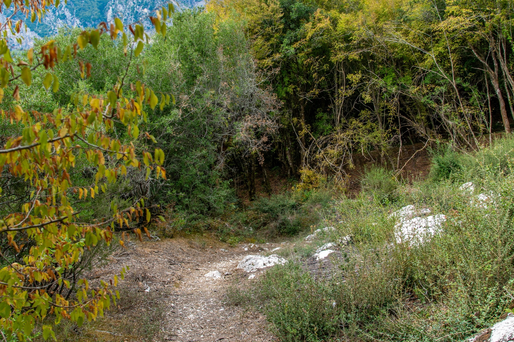
The path of Vidra is a riverside path in the middle valley of Arachthos that connects the prefectures of Ioannina and Arta and belongs to the municipalities of North Tzoumerka and Arta. Most of it stretches along the west bank of the river. It starts from the bridge of Plaka, crosses the Tzari Bridge, and ends at the hydropower complex (watermill, whirlpool, possing tub) in the flatland of Skoupa. It is 17,560 km long and runs through the settlements Plaka, Raftanaion, Monolithi, Platanoussa, Dafnoti, and Skoupa, while three vertical sections complete the d.
The path is accessible through the Plaka Bridge or vice versa from the Tzari bridge, the villages, and the vertical routes (A2, A3, and A4). It is fully labeled and secure. There are springs, water fountains, and kiosks for the hikers’ rest along the path.
The actions that take place are:
– Hiking by mountaineering clubs and individual visitors.
– Visits of primary and secondary schools from all over Greece, mainly on the vertical path A2 of Skoupa.
– Mountain running race (Vidra’s Trail) once a year.