

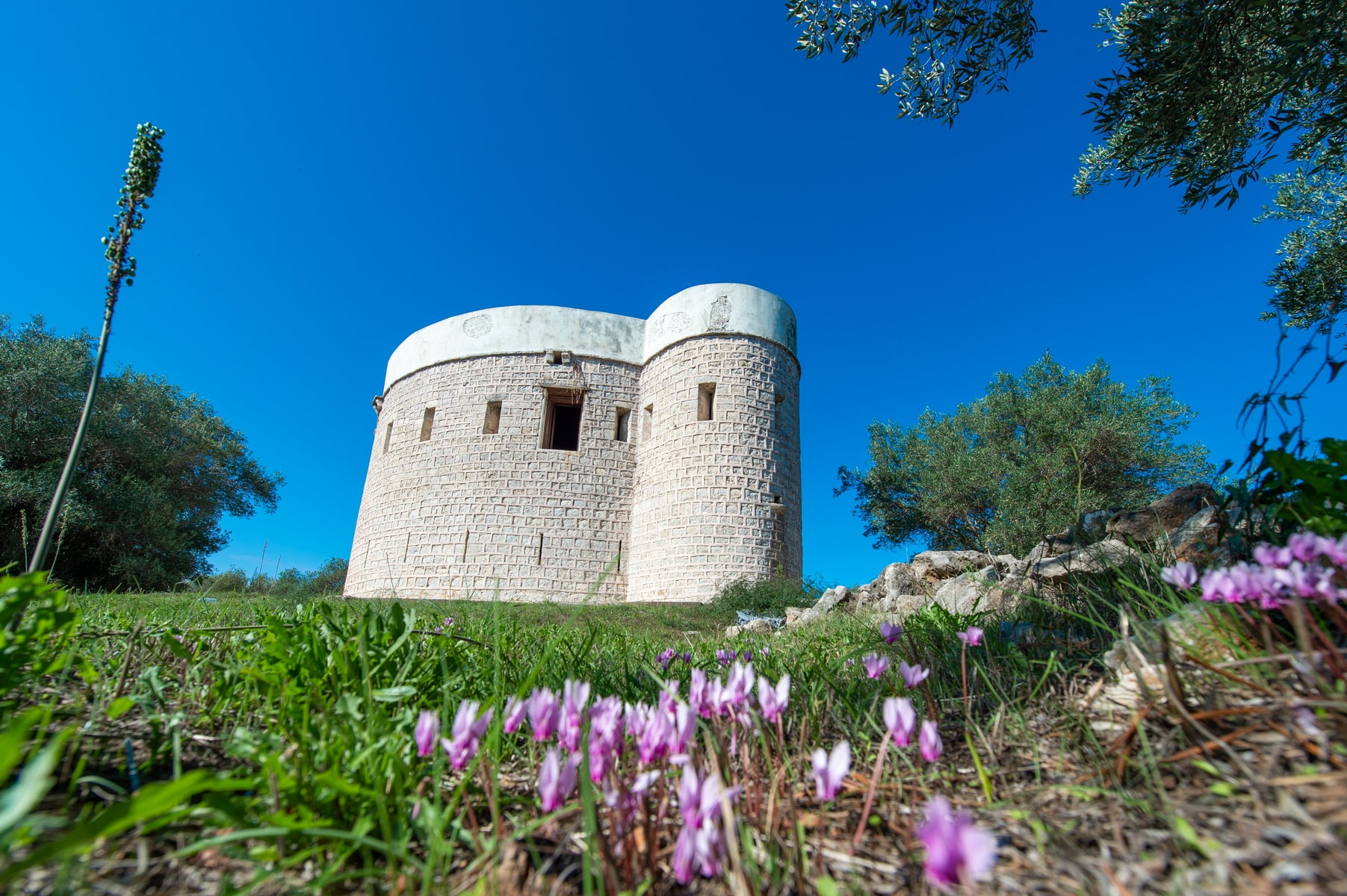
Koulia castle is a small, well-preserved fortress on the island of Koronisia, in the southern part of the settlement. It overlooks the Amvrakikos gulf together with the “”twin”” and identical castle of Laskara, in the homonymous cape that penetrates the gulf from the side of Preveza.
The word “”koulia””, as it was initially called, comes from the Turkish “”kulla”” (Persian “”qulla””) and means the top or tower. Such works are part of a defense network located at critical points from where they supervised the surrounding area.
The fortress of Koronisia is believed to have been built in the early 19th century by Ali Pasha, with designs of the French army colonel Guillaume de Vaudoncourt and under the supervision of the Italian engineer Monteleone.
They are the same architects who built the Pantocrator Fortress in Preveza, the Bastion of Pefkakia in Preveza, and the Fortress of Anthousa in Parga.
According to another hypothesis, the fort was built much later, probably in 1860, at a time when the Turks were trying to strengthen their border defense on the north side of the Amvrakikos Gulf. The area was then on the frontier between Greece and Turkey.
There is, however, the view expressed by Konstantinos Dem. Rosos, according to which the fortress is much older and was originally built by the Venetians. After the battle of Koronisia in 1829 it was occupied by the Greek Army. In 1850, after the exchange of Euboea with Amvrakikos, it fell again into the hands of the Turks.
The castle is circular with two high towers that connect to its perimeter in opposite positions. It has an entrance that is elevated and accessible by a ramp. Today it occasionally hosts various cultural events and sometimes functions as a lending library.
Ancient
Small Theater of Ambracia
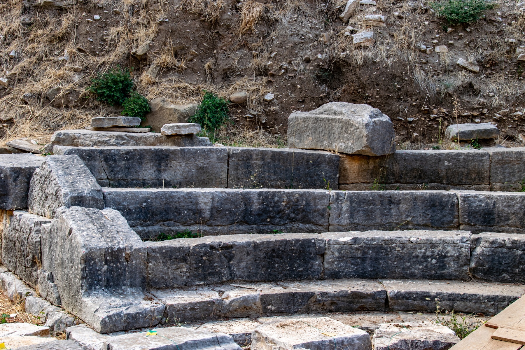
And in Amvrakia a temple of the same goddess (Afrodite) and a hero-shrine of Aeneas near the small theater. In this shrine there was a small archaic statue of wood, said to be of Aeneas”
Dionysios of Alikarnassos, Roman Archeology 1.50.4.
The Dionysios of Alikarnassos’ testimony of the 2nd century AD about the existence and location of the small theater of Amvrakia was an important source for its identification.
Survey: The theater was first excavated in 1976 after a few months of research on St. Constantine street, occasioned by an excavation to construct a new building. Excavation works started again in 2011. They continued within the framework included in the NSRF project “”Works for the Promotion and Shaping of the archaeological site of the Small Theater of ancient Amvrakia”” (2014-2020)
Location: The small theater is the smallest known preserved theater in Greece. It was found near St. Konstantinos church and is part of the administrative and religious center of the ancient city, as evidenced by the adjacent public buildings. The post-archaic church of Apollo on Vasilios Pyrrou Street, the Large Theater on Tsakalov Street, and the Rector’s Office, preserved beneath the square and the church of Agia Theodora, are the most important nearby structures. In addition, buildings of the ancient city and a paved street were detected in the theater’s surrounding area.
Construction: The theater was not built on a natural hill as was customary, but on an embanked slope on the remains of a bath complex with pebble mosaics dating to the middle of the 4th century BC. A robust retaining wall supports and delimits the theater to the east.
Parts of the theater have been revealed: Part of the koilon (auditorium) and the parodoi (the two entrances between the scene and the seats), the orchestra (the circular area facing the audience), and the western part of the proskenion’s (front side of the scene) pillar.
The koilon, made of good quality limestone, is crossed by two radial staircases that divide it into three sections with five rows of seats, while the existence of another row is very likely. The seats were made of stone, while the absence of the Proedria (the front seats, reserved for officials and priests) is unusual. Three rows of seats are preserved in both side sections and four in the central one.
The orchestra has the shape of a perfect circle, with a diameter of 6.70 m.
The proscenion was a 10 m long stone building. Its facade was probably decorated with six Ionic half-columns, while a slate-roofed rainwater pipe ran over its entire length.
Dating: According to the architectural elements, the small theater was built at the end of the 4th c. – the beginning of the 3rd c. BC, during the reign of Pyrrhus, that is, during the heyday of Amvrakia, when the city became the kingdom’s capital.
The Large Theater: The Large Theater of Amvrakia, as already mentioned, was located nearby. However, it is impossible to be unearthed, and we know few things about it. Its location has been detected beneath the modern buildings of Arta, but unfortunately, its proximity to these structures leaves no room for further exploration.
Western Nekropolis of Ambracia
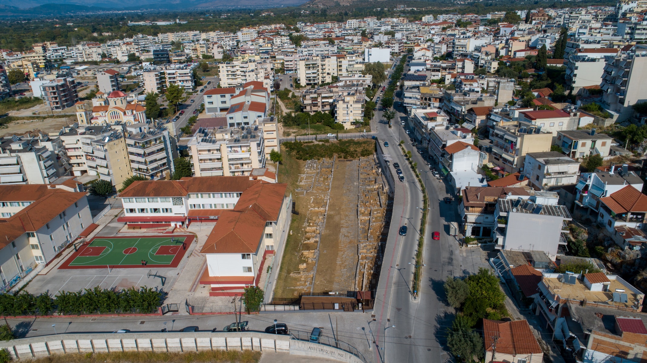
The city: Amvrakia was founded as a colony of the Corinthians in 625 BC. in the fertile plain defined by the northern slopes of the Peranthi hill and the navigable river Arachthos that surrounds it for the most part. The natural fortification was strengthened by its walls, which are estimated to be 4.5 km long. Apart from the land’s abundance, the city held a privileged geographical position, located near the sea of the Amvrakikos and on the only exit of Epirus to the South. Inside the walls, the geometric urban design formed large residential areas, measuring 150×30 meters, separated by wide roads up to 5 meters wide. The public spaces with the market and the temples were developed to the northwest. The ancient city is located beneath the present city of Arta and occupies half of its area.
The western necropolis and the sacred road: The two necropoleis, which were in constant use from the city’s foundation until its decline, stretched outside the Amvrakia walls, on the eastern and western slopes of Peranthi hill. The cemetery to the west that was organized along the sacred streets was larger and more impressive. 12m wide, the burial road was paved or concrete and led from the South Gate to the city’s port in the Amvrakikos Gulf. To date, a part of it, 300m long, has been revealed near the National Stadium.
The sacred street was surrounded by monumental burial enclosures and burials on various levels. The most common burial method was burial in a simple pit or a cist grave made of limestone slabs. Cist graves were often used as family graves, while cremation was common. The urns, where the remains of the cremations ended up, were placed in square burial cases or pits or cist graves. Grave goods accompanied the dead, and the graves were marked with tombstones bearing their names. These inscribed burial columns from domestic limestone are a unique assemblage as Epirus is concerned. Their special feature is the simple decoration, which is limited to branches of ivy, olive, or oak, and the frequent inscription of the patronymic next to the deceased’s name. The nationality, the profession, or the invocation “”ΧΑΙΡΕ”” (be happy in Greek) is rarely mentioned. The tombstones of Amvrakia were made between 500 and 200 BC by local craftsmen.
Polyandrio (today on Kommenou Street): Polyandrio, a cenotaph founded by the city around 600 BC to honor the dead people of Amvrakia and Corinth, who were killed in a battle, is one of the burial monuments. The monumental construction has a length of 12.40m, a width of 8m., and a height greater than 2.40 m. But what makes it unique is the word “”Anprakia”” written on its facade, which is the oldest reference to the city’s name. The inscription is written boustrophedon (a style of writing in which alternate lines of script are reversed) and stoichedon (the letters were aligned vertically and horizontally). The monument’s sanctity remained over the centuries, as it operated as a cemetery with a three-aisled nave during the Byzantine era.
The Polyandrion of Ambracia
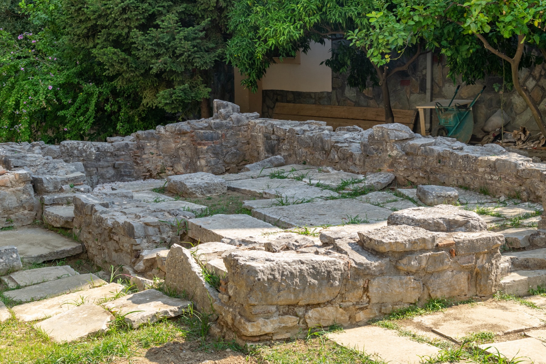
Polyandrio (in Kommenou Street): Polyandrio, a public memorial dedicated to the dead of a naval battle at the mouth of the Acheron river in the late 7th century, is located in the most important and well-organized western necropolis of Amvrakia.
The cenotaph dates back to around 600 BC. and lies on the east side of the necropolis, a short distance from the wall’s gate. It has a Π shape, a highly elaborate construction of monumental dimensions. The facade, 12.40 m long and 2.50 m high, consists of a base and a superstructure with five rows of stones. The second and fifth rows protrude, forming an undulation that continues to the sides for a total length of 8m. The maximum height of the monument is 2.50 m., while at the top of the facade, the upper row of stones has an engraved inscription. The inscription, written boustrophedon (a style of writing in which alternate lines of script are reversed) and stoichedon (the letters were aligned vertically and horizontally) in the archaic Corinthian alphabet, is an elegiac epigram, referring to the city’s public mourning for its dead heroes. It is the only known testimony to date concerning the typical behavior of the people of Amvrakia. In addition, the lyrics of the inscription are of particular interest, as they preserve the oldest reference to the city’s name: “”Anprakia””.
The monument’s sanctity remained over the centuries, as it operated as a cemetery with a three-aisled nave during the Byzantine era.